
197 posts
- 400 , -, 129 . 1667 . 1911 , , , . , .


Каинды - 400 метровое озеро в Казахстане, в долине Тянь-Шаня, в 129 км от города Алматы. Оно расположено среди хвойного леса на высоте 1667 метров над уровнем моря. Озеро Каинды образовалось после землетрясения 1911 года, которое вызвало большой оползень, заблокировавший одно из ущелий горного хребта Кунгей Алатау, образовав естественную плотину. Впоследствии, дождевая вода заполнила долину и наполнила озеро.
Озеро славится своей красотой подводного леса. Макушки самых высоких деревьев поднимаются прямо из воды. Средняя глубина составляет 20 метров, а в некоторых местах доходит до 30 метров. Вода в озере настолько холодная (даже летом температура воды не превышает 6 градусов), что могучие сосны по-прежнему остаются полузамороженными на своих местах, даже 100 лет спустя. Благодаря чистой горной воде, можно увидеть глубины озера. Вода в озере пресная, практически не содержит растворенных солей и идентична той воде, которая подвергается многоуровневой очистке в лаборатории.Зимой поверхность озера замерзает и становится прекрасным местом для ловли форели и подлёдного дайвинга.
Этот природный объект внесён в список особо охраняемых природных территорий со статусом природоохранного и научного учреждения, а также входит в Государственный национальный природный парк "Кольсайские озёра".
Kaindy is a 400-meter lake in Kazakhstan, in the Tien Shan Valley, 129 km from the city of Almaty. It is located among a coniferous forest at an altitude of 1667 meters above sea level. Kaindy Lake was formed after the earthquake of 1911, which caused a large landslide that blocked one of the gorges of the Kungei Alatau mountain range, forming a natural dam. Subsequently, rainwater filled the valley and filled the lake.
The lake is famous for its underwater forest beauty. The tops of the tallest trees rise straight out of the water. The average depth is 20 meters, and in some places it reaches up to 30 meters. The water in the lake is so cold (even in summer the water temperature does not exceed 6 degrees) that the mighty pines still remain semi-frozen in their places, even 100 years later. Thanks to the clear mountain water, you can see the depths of the lake. The water in the lake is fresh, contains practically no dissolved salts and is identical to the water that is subjected to multi-level purification in the laboratory.In winter, the surface of the lake freezes and becomes a great place for trout fishing and ice diving.
This natural object is included in the list of specially protected natural territories with the status of an environmental and scientific institution, and is also included in the Kolsai Lakes State National Natural Park.
Источник://discoverynn.ru/blog/kazakhstan/ozero-kaindy-neobychnaya-dostoprimechatelnost-na-yuge-kazakhstana/ , ://newtimes.kz/obshchestvo/155196-podvodnyj-les-ozera-kaindy-udivil-kazahstancev,//tourlenta.com/blog/316-podvodnij-les-na-ozere-kaindi,m.vk.com/wall-222521402_9950,//www.stena.ee /blog /zatoplennyj-les-odno-iz-samyh-krasivyh-mest-kazahstana,//dzen.ru /a/ZOZQ8LxcWxUAPkQe,aveneerdmc.com/ru/inspiration/kaindy.
-
 mortallyswimmingllama liked this · 8 months ago
 -
 dreamerdivinginheadfirst reblogged this · 9 months ago
 -
dreamerdivinginheadfirst liked this · 9 months ago
-
 vladimarinas-blog liked this · 9 months ago
 -
 sanoups liked this · 9 months ago
 -
 coydogbb liked this · 9 months ago
 -
 beetman liked this · 9 months ago
 -
 snapeycat liked this · 9 months ago
 -
 angelayasmim liked this · 9 months ago
 -
 pechalnii reblogged this · 9 months ago
 -
 typikcyd liked this · 9 months ago
 -
 dream-world-universe liked this · 10 months ago
 -
 northameicanblog liked this · 10 months ago
 -
 verycolourfulflipflops reblogged this · 10 months ago
 -
 iamblessedtruly liked this · 10 months ago
 -
 enamay reblogged this · 10 months ago
 -
 proartspb liked this · 10 months ago
 -
 botchedlobotomy914 liked this · 10 months ago
 -
 clockworkomen reblogged this · 10 months ago
 -
clockworkomen liked this · 10 months ago
-
 dsx12 liked this · 11 months ago
 -
 juniperize liked this · 11 months ago
 -
 saltykingdreamland liked this · 11 months ago
 -
 helfriend liked this · 11 months ago
 -
 hope-in-shadows liked this · 11 months ago
 -
 christabelq liked this · 11 months ago
 -
 bluesdeluxe liked this · 11 months ago
 -
 phantomofthering liked this · 11 months ago
 -
 imortellekim liked this · 11 months ago
 -
 huzur-un liked this · 11 months ago
 -
 williamskyw liked this · 11 months ago
 -
 kojj liked this · 11 months ago
 -
 naser1963 liked this · 11 months ago
 -
 alriks-small-room liked this · 11 months ago
 -
 belcit reblogged this · 11 months ago
 -
belcit liked this · 11 months ago
-
 enablesomething liked this · 11 months ago
 -
 leontinrau liked this · 1 year ago
 -
 thelostdreamsthings liked this · 1 year ago
 -
 hope--dies--last liked this · 1 year ago
 -
 artowot liked this · 1 year ago
 -
 xposure-and-things liked this · 1 year ago
 -
 abdalla-23 liked this · 1 year ago
 -
 zaharprostoi liked this · 1 year ago
 -
 praline1968 liked this · 1 year ago
More Posts from Vestaignis


Медуза Яичница (Котилориза) Cotylorhiza tuberculata.
У медузы котилоризы есть веселое название «жареное яйцо» или «медуза яичница». Эта медуза в первую очередь примечательна своей внешностью — ее купол имеет выпуклость, чем-то напоминающую желток яичницы. Она может достигать приличных размеров, до 35-40 см в диаметре,а периметр их диска разделен на 16 равных долей, которые в свою очередь разделены еще на более чем сотню более мелких долей. В условиях домашнего содержания эта медуза вырастает до 5-8 см в диаметре купола.
«Медуза яичница» является одним из самых распространенных видов средиземноморских медуз. Ее также можно встретить в Адриатическом и Эгейском морях, а так же в Атлантическом и Тихом океане, на небольших глубинах теплой океанской воды до 165 футов (50,2 м).
Медузы Котилоризы могут передвигаться автономно, используя силу подводных течений. У Котилоризы есть стрекательные клетки, в которых содержится токсическое вещество, а также очень небольшое жало, к счастью, для людей такие медузы безопасны. Надумаете погладить медузу-яичницу, гладьте сверху — где нет стрекательных клеток. Обратите внимание, у ряда дайверов после контакта с этим животным наблюдают сенсибилизацию — приобретение организмом повышенной чувствительности к чужеродным веществам. Например, аллергия на морепродукты. Иногда мелкие рыбки находят защиту от хищников в щупальцах этой медузы.
Jellyfish cotylorhiza has the fun name of "fried egg" or "fried egg jellyfish." This jellyfish is primarily notable for its appearance - its dome has a bulge that is somewhat reminiscent of the yolk of a fried egg.It can reach decent sizes, up to 35-40 cm in diameter, and the perimeter of their disk is divided into 16 equal lobes, which in turn are divided into more than a hundred smaller lobes. When kept at home, this jellyfish grows to 5-8 cm in dome diameter.
The "fried egg jellyfish" is one of the most common types of Mediterranean jellyfish. It can also be found in the Adriatic and Aegean seas, as well as in the Atlantic and Pacific oceans, in shallow depths of warm ocean water up to 165 feet (50.2 m).
Cotylorhiza jellyfish can move autonomously using the power of underwater currents. Cotylorhiza has stinging cells that contain a toxic substance, as well as a very small sting; fortunately, such jellyfish are safe for humans. If you decide to stroke a fried egg jellyfish, stroke it from above - where there are no stinging cells. Please note that a number of divers, after contact with this animal, experience sensitization - the body acquires increased sensitivity to foreign substances. For example, an allergy to seafood. Sometimes small fish find protection from predators in the tentacles of this jellyfish.
Источник://www.youtube.com/watch?v=2_w8Ffw3aXM&ab _channel =Psyche%26Wilczykurcgalopkiemprzez%C5%9Bwiat,/pikabu.ru/story/kotiloriza_cotylorhiza_tuberculata_v_mire_morskikh_chudes_11036095,/gagaru.club/29547-kotiloriza-meduza.html,


Сахалин — крупнейший остров России — расположен на Дальнем Востоке, у побережья Евразии. По площади он сравним с Чехией или Сербией и лишь немного уступает Ирландии. Омывается сразу двумя морями — холодным Охотским и более тёплым Японским.От южной точки острова до японского острова Хоккайдо всего 44 километра.
Первые люди поселились здесь ещё в доисторические времена. Самой древней стоянке человека, обнаруженной археологами на Сахалине, около 230 тысяч лет. Местное коренное население — их осталось около трёх тысяч человек — племена оленеводов уйльта и эвенков и рыболовов нивхов до сих пор живут согласно древним традициям.
Большинство путешественников едет на Сахалин ради природных красот. Здесь есть действующие вулканы, горячие термальные источники, и изумрудно-зелёные скалы. Растительность на острове довольно необычная. На севере можно прогуляться по тайге, а на юге и западе — увидеть несколько видов лиан и курильский бамбук. А ещё на Сахалине есть «ботаническое чудо света»: папоротники, крапива, гречиха и другие травянистые растения в некоторых местах вырастают на высоту до 3-5 метров. При этом на материке из их семян появляются растения обычной высоты.
На Сахалине умеренный муссонный климат с высоким уровнем влажности, дождливым летом и холодной, снежной зимой. Летом часто появляются туманы, создающие таинственную атмосферу. В конце лета и начале осени бывают тайфуны. Осень мягкая, яркая и тёплая, почти без дождей. Погода на Сахалине непредсказуемая, поэтому лучше быть готовым к любым капризам природы.
На озере Тунайча гнездятся разные виды птиц, а на Тюленьем острове близ Сахалина находится крупное лежбище тюленей и огромные птичьи базары. В окрестностях самой высокой точки острова — горы Вайды — расположены карстовые пещеры. С вершины горного хребта Жданко открывается вид на живописные окрестности. На мысе Великан можно увидеть природные арки, гроты и столбы, которые возникли под воздействием ветра и соленой морской воды.
Подходящее для туризма время на Сахалине — с мая по сентябрь. К маю почти везде сходит снег и уже можно отправляться в путешествие по острову.А самое популярное для путешествий по Сахалину время — тёплый и солнечный август. В этом месяце лучше всего исследовать дальние уголки острова, купаться в море (вода в этом месяце иногда прогревается до +21 °C) и пробовать лесную голубику и чернику.
Sakhalin, Russia's largest island, is located in the Far East, off the coast of Eurasia. In terms of area, it is comparable to the Czech Republic or Serbia and is only slightly inferior to Ireland. It is washed by two seas at once — the cold Sea of Okhotsk and the warmer sea of Japan.It is only 44 kilometers from the southern point of the island to the Japanese island of Hokkaido.
The first people settled here in prehistoric times. The oldest human site discovered by archaeologists on Sakhalin is about 230 thousand years old. The local indigenous population — there are about three thousand people left — the tribes of reindeer herders Uilta and Evenks and fishermen Nivkh still live according to ancient traditions.
Most travelers go to Sakhalin for the sake of natural beauty. There are active volcanoes, hot thermal springs, and emerald green rocks. The vegetation on the island is quite unusual. In the north you can walk through the taiga, and in the south and west you can see several types of lianas and Kuril bamboo. And also on Sakhalin has a "botanical wonder of the world": ferns, nettles, buckwheat and other herbaceous plants in some places grow to a height of 3-5 meters. At the same time, plants of normal height appear from their seeds on the mainland.
Sakhalin has a temperate monsoon climate with high humidity, rainy summers and cold, snowy winters. In summer, fogs often appear, creating a mysterious atmosphere. There are typhoons in late summer and early autumn. Autumn is mild, bright and warm, with almost no rain. Weather on Sakhalin is unpredictable, so it's better to be prepared for any whims of nature.
Different species of birds nest on Lake Tunaicha, and on Seal Island near Sakhalin is home to a large seal rookery and huge bird markets. Karst caves are located in the vicinity of the highest point of the island — Mount Vida. From the top of the Zhdanko mountain range, you can enjoy a view of the picturesque surroundings. At Cape Giant, you can see natural arches, grottoes and pillars that arose under the influence of wind and salty sea water.
A suitable time for tourism on Sakhalin — from May to September. By May, snow is falling almost everywhere and you can already go on a trip around the island.And the most popular time for traveling around Sakhalin is warm and sunny August. This month, it is best to explore the far corners of the island, swim in the sea (the water sometimes warms up to +21 °C this month) and try wild blueberries.
Источник://bolshayastrana.com/blog/top-dostoprimechatelnostej-sahalina-229,//experience.tripster.ru/articles/sahalin/, /sakhtravel .com/tury-po-sahalinu/tury/tvoya_yarkaya_zima_na_sakhalin, ://wikiway.com/russia/sakhalin/photo/, https://www.tripadvisor .ru/LocationPhotos-g4355184-Sakhalin_Sakhalin_ Oblast_Far _Eastern _District.html,//www.culture.ru/institutes/34988/ostrov-sakhalin, ://tonkosti.ru/%D0%A4%D0%BE%D1%82%D0%BE_%D0%A1%D0%B0%D1%85%D0%B0%D0%BB%D0%B8%D0%BD%D0%B0?utm_referrer=https%3A%2F%2Fwww.google.com%2F.


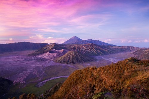

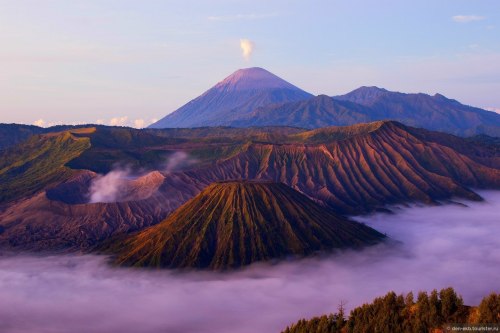


Вулкан Бромо на о. Ява, расположенный в национальном парке Бромо-Тенгер-Семеру, взмывает на высоту 2392 м и считается самым активным и «ненасытным» на острове. Последние 20 лет он постоянно «дышит», его огромный кратер диаметром 600 м все время наполнен дымом, а все вокруг, включая тропы и дороги вокруг вулкана, усыпаны густым слоем пепла. Однако это абсолютно не мешает Бромо привлекать многочисленных туристов, которые приезжают, чтобы полюбоваться фантастическими «лунными» пейзажами, посмотреть со смотровой площадки на могучий вулкан на рассвете, когда его склоны окрашиваются в розовые и золотые тона, и, наконец, совершить восхождение к кратеру и пройтись по его кромке на высоте птичьего полета.
Название Бромо происходит от яванского имени бога Брахмы, и находится вулкан посреди песчаной равнины, которую местные жители называют Сегара Веди, что значит «Песчаный океан». Здесь же, у северных склонов Бромо стоит индуистский храм Пура Лухур Потен, построенный из темных вулканических камней. Каждый год, начиная с XV в., тенгеры (яванская народность) целый месяц отмечают праздник Ядня Касада, во время которого они поднимаются к кратеру и сбрасывают в жерло вулкана жертвоприношения богам – фрукты, овощи, цветы, рис, кур и даже домашний скот, причем живьем. Именно поэтому Бромо и называют «ненасытным».
Лучшее время для посещения вулкана - с апреля по октябрь. Сезон дождей длится с декабря по март. Днем здесь прохладно, температура не превышает +20°C.
Mount Bromo on Java Island, located in the Bromo Tengger Semeru National Park, rises to a height of 2,392 m and is considered the most active and “insatiable” on the island. For the last 20 years, it has been constantly “breathing”, its huge crater with a diameter of 600 m is constantly filled with smoke, and everything around, including paths and roads around the volcano, is strewn with a thick layer of ash. However, this does not prevent Bromo from attracting numerous tourists who come to admire the fantastic “lunar” landscapes, look at the mighty volcano from the observation deck at dawn, when its slopes are painted in pink and gold tones, and, finally, climb to the crater and walk along its edge at a bird's eye view.
The name Bromo comes from the Javanese name of the god Brahma, and the volcano is located in the middle of a sandy plain, which the locals call Segara Wedi, which means “Sand Ocean”. Here, on the northern slopes of Bromo, there is a Hindu temple, Pura Luhur Poten, built of dark volcanic stones. Every year, since the 15th century, the Tenggerese (Javanese people) celebrate the Yadnya Kasada festival for a whole month, during which they climb to the crater and throw sacrifices to the gods into the volcano's mouth - fruits, vegetables, flowers, rice, chickens and even livestock. That is why Bromo is called "insatiable".
The best time to visit the volcano is from April to October. The rainy season lasts from December to March. It is cool here during the day, the temperature does not exceed +20°C.
Источник://t.me/krasivye_mesta_turizm,/vsegda-pomnim.com / vulkany/6053-vulkan-bromo-76-foto.html,//photopole.ru/krasivye-kartinki/vulkany-krasivye,/geosocks.com/bromo-volcano/, //thinking.ru/trips/indonesia/vulkan-bromo-na-indoneziyskom-ostrove-yava/,www.pac.ru/guide/indonesia/java/landmarks/mount-bromo/,/www.tripadvisor.ru/Attraction_Review-g297710-d2307699-Reviews-Bromo_Tengger_Semeru_Adventure-Malang_East _Java_ Java.html,//www.tourister.ru/world/asia/indonesia/city/malang/volcano/30191.


Гора Кука (Аораки) - наивысшая точка Новой Зеландии, высота которой составляет 3754 метра над уровнем моря, расположена в западной части Южного острова, в новозеландских Южных Альпах. Гора состоит из трёх пиков - самый низкий из них имеет высоту 3593 метра над уровнем моря, средний - 3717 метров и самый высокий - 3754 метра. Гора Кука сложена из кристаллических пород, имеет форму седла с крутыми склонами, а её вершина покрыта вечными снегами и ледниками. Вдоль восточного фланга горы спускается знаменитый ледник Тасмана - крупнейший ледник в Новой Зеландии, протяжённостью 29 километров и площадью 156,5 квадратных километров. Нижняя часть горных склонов покрыта уникальными дождевыми лесами умеренного климата и живописными альпийскими лугами, в которых произрастают эндемичные виды растений и редкие виды животных, встречающиеся только в Новой Зеландии.
Для маори, коренного населения Новой Зеландии, Аораки является священной горой, на языке племени Нгай Таху название горы означает "большое белое облако". Английское название Mount Cook (Гора Кука) дал горе в 1851 году капитан Джон Лорт Стокс в честь знаменитого мореплавателя Джеймса Кука. С момента открытия горы европейцами, её вершина постоянно манит альпинистов со всего мира. Несмотря на то, что Аораки - далеко не самая высокая гора на планете, она является технически очень сложной для восхождения. Огромную опасность для альпинистов представляют резкая смена погоды, сильные снегопады, высокий уровень обледенения скал, большие трещины ледников и высокая вероятность внезапного схода лавин. Только с начала XX века при восхождении на гору Кука погибло около 80 альпинистов, что делает её самым смертоносным пиком в Новой Зеландии. Не даром в легендарной эпопее Джона Толкина "Хоббит, или Туда и обратно", "Властелин колец" и "Сильмариллион" гора Кука стала прототипом пика Карадрас - одного из высочайших пиков Мглистых гор в Средиземье. Именно под Карадрасом был построен великий город гномов Казад-Дум
В 1953 году на территории вокруг горы Кука был создан Национальный парк Маунт-Кук, в который входят 19 горных пиков высотой более 3000 метров над уровнем моря и 8 (из 12) крупнейших ледников в Новой Зеландии. Парк является частью района Те-Вахипунаму, внесенного в список Всемирного наследия ЮНЕСКО за выдающуюся природную ценность. Помимо занятий альпинизмом (восхождение на вершину разрешено только опытным альпинистам в сопровождении горных проводников), посетители парка могут заняться скалолазанием, трекингом, горным велосипедом, охотой и насладиться невероятным зрелищем самого "звёздного" ночного неба на Земле. Во время прогулок по горным тропам можно увидеть попугая кеа - единственного в мире попугая, эндемика Новой Зеландии, обитающего на высоте 1500 метров над уровнем моря и выше.
Mount Cook (Aoraki) is the highest point in New Zealand, with an altitude of 3,754 meters above sea level, located in the western part of the South Island, in the New Zealand Southern Alps. The mountain consists of three peaks - the lowest of which is 3,593 meters above sea level, the middle one is 3,717 meters, and the highest is 3,754 meters. Mount Cook is composed of crystalline rocks, has the shape of a saddle with steep slopes, and its summit is covered with eternal snow and glaciers. Along the eastern flank of the mountain descends the famous Tasman Glacier - the largest glacier in New Zealand, with a length of 29 kilometers and an area of 156.5 square kilometers. The lower part of the mountain slopes is covered with unique temperate rainforests and picturesque alpine meadows, in which endemic species of plants and rare species of animals grow, found only in New Zealand.
For the Maori, the indigenous people of New Zealand, Aoraki is a sacred mountain; in the language of the Ngai Tahu tribe, the mountain's name means "large white cloud". The English name Mount Cook was given to the mountain in 1851 by Captain John Lort Stokes in honor of the famous navigator James Cook. Since the discovery of the mountain by Europeans, its summit has constantly attracted climbers from all over the world. Despite the fact that Aoraki is far from the highest mountain on the planet, it is technically very difficult to climb. Extreme weather changes, heavy snowfalls, high levels of icing on the rocks, large glacier cracks and a high probability of sudden avalanches pose a huge danger to climbers. Since the beginning of the 20th century alone, about 80 climbers have died while climbing Mount Cook, making it the deadliest peak in New Zealand. It is not for nothing that in the legendary epics of John Tolkien "The Hobbit, or There and Back Again", "The Lord of the Rings" and "The Silmarillion" Mount Cook became the prototype of the peak of Caradhras - one of the highest peaks of the Misty Mountains in Middle-earth. It was under Caradhras that the great city of the dwarves Khazad-dum was built.
In 1953, Mount Cook National Park was created on the territory around Mount Cook, which includes 19 mountain peaks over 3,000 meters above sea level and 8 (out of 12) of the largest glaciers in New Zealand. The park is part of the Te Wahipounamu area, listed as a UNESCO World Heritage Site for its outstanding natural value. In addition to mountaineering (climbing to the summit is only permitted for experienced climbers accompanied by mountain guides), visitors to the park can go rock climbing, trekking, mountain biking, hunting and enjoy the incredible spectacle of the most "starry" night sky on Earth. While walking along the mountain trails, you can see the kea parrot - the only parrot in the world, endemic to New Zealand, living at an altitude of 1,500 meters above sea level and higher.
Источник://shark-er.livejournal.com/121080.html,/tury.ru/sight/id/ 14721-gora-kuka-aoraki-14721,/www.tripadvisor.ru/Attraction_ Review-g658483-d4080009-Reviews-Aoraki_Mt_Cook- Mt_Cook _Village_Aoraki_Mount_Cook_National_Park_Te_Wahipounamu_Mac.html,/www.nik-m.com/regiony/kenterberi/aoraki-maunt-kuk-samaya-vysokaya-gora-novozelandskikh-ostrovov/,//t.me/ borderlesstravel.


Живописные тропические закаты на острове Сайпан.
Остров Сайпан (Saipan) является самым крупным из Северных Марианских островов. Он расположен в Тихом океане на юге Марианского архипелага. Остров площадью 120 кв. км имеет вытянутую форму, все берега Сайпана причудливо изрезаны, на юго-восточной стороне дугообразный берег образует обширный морской залив, на южном выступе которого располагается международный аэропорт. На расстоянии около 300 км от восточного побережья острова расположен знаменитый Марианский жёлоб, самая глубокая океаническая впадина мира — 11 775 метров ниже уровня моря.
Атолл внесён в Книгу Рекордов Гинесса за самую постоянную температуру в течение года и суток. Этот показатель равен +27 °С, то есть тропическая летняя погода стоит 365 дней в году. Температура воды днем 25`C. Насекомых (мух, комаров) нет. Временами идут проливные дожди, когда за минуту можно промокнуть насквозь. Они обычно внезапно начинаются и также заканчиваются, длятся недолго, и дождь можно переждать под ближайшей пальмой.
Остров Сайпан небольшой, его можно обойти за 4 часа..На Сайпане, как и на прочих Марианских островах, нет городов в традиционном понимании этого термина. Центром острова считается Гарапан. Здесь самое большое скопление магазинов, кафе, ресторанчиков. А также здесь находится лучший пляж Сайпана - пляж Микро Бич.
Picturesque tropical sunsets on the island of Saipan.
Saipan Island is the largest of the Northern Mariana Islands. It is located in the Pacific Ocean in the south of the Mariana Archipelago. Island with an area of 120 sq. km has an elongated shape, all the shores of Saipan are intricately indented, on the south-eastern side the arched coast forms a vast sea bay, on the southern ledge of which the international airport is located. At a distance of about 300 km from the eastern coast of the island is the famous Mariana Trench, the deepest oceanic trench in the world - 11,775 meters below sea level.
The atoll is included in the Guinness Book of Records for the most constant temperature throughout the year and day. This figure is +27 °C, that is, tropical summer weather is 365 days a year. Water temperature during the day is 25`C. There are no insects (flies, mosquitoes). At times there are torrential rains, when you can get wet through and through in a minute. They usually start suddenly and also end, they don’t last long, and you can wait out the rain under the nearest palm tree.
The island of Saipan is small, you can get around it in 4 hours. On Saipan, like on the other Mariana Islands, there are no cities in the traditional sense of the term. Garapan is considered the center of the island. Here is the largest concentration of shops, cafes, and restaurants. And also here is the best beach in Saipan - Micro Beach.
Источник:/telega.in/c/krasivye_mesta_turizm,//primoravtotour.ru/guide/marianskie_ostrova/sajpan/,/www.tripadvisor.ru/Tourism-g60716-Saipan_Northern_Mariana_Islands-Vacations.html, //tour.shamora. info,/cttour.ru/tury/sajpan/charter-na-sajpan/,/dxnews.com/ru/kh0-jr1fkr/,/dxnews.com/ru/KH0-K6WP_Saipan/,/mandarin-travel.com/country/saypan/.