
197 posts
( ), . . . . . , , . 8 . - 40 . , 19341935 , 32 , . , - . , . 30 , . : -, , - . , .


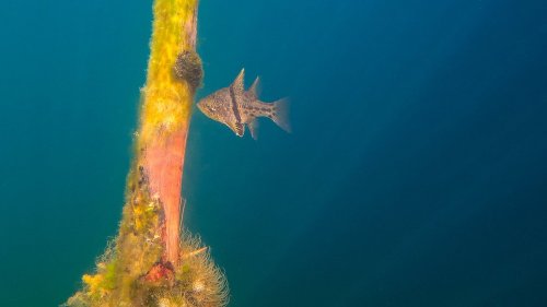
Озеро Сукко (Кипарисовое озеро), или Голубое озеро — одна из самых популярных и фотогеничных локаций в окрестностях Анапы. Удивительные деревья с узловатыми корнями и приятным смолистым ароматом растут здесь прямо из воды. О происхождении названия озера существует множество предположений. С адыгейского топоним можно перевести как «водоем кабанов». Существует также вариант трактовки «Сукко» как «су» — вода и «къко» – свинья или дельфин. Озеро в Сукко было создано искусственно путем строительства плотины на реке, впадающей в Черное море, что привело к затоплению долины. Этот водоем занимает площадь всего 8 гектаров. Высота Кипарисового озера - 40 м над уровнем моря. Особую известность озеру принес уникальный эксперимент, проведенный в 1934–1935 годах, когда были посажены 32 болотных кипарисов, которые успешно прижились и выросли. Изначально кипарисы были посажены на сухой земле, однако из-за значительных изменений рельефа территории они со временем оказались в воде. В периоды засухи уровень воды в озере понижается, обнажая обширную корневую систему деревьев. Кипарисы достигают внушительной высоты почти в 30 метров, а их стволы могут быть шириной до полуметра. Роща прекрасна практически в любой сезон: весной свежая листва хвойных деревьев нежно-зелёная, летом приобретает более тёмный и насыщенный оттенок, а осенью полыхает ярко-оранжевым или красным цветом. К зиме деревья полностью сбрасывают листву, обнажая ветвистые кроны — в чём тоже есть своя красота.
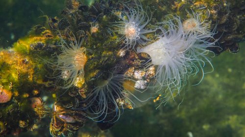
Из-за обилия известняковых отложений в зависимости от освещения озеро Сукко может менять цвет от нежного молочно-голубого до насыщенного бирюзового. Голубое озеро не только известно своими кипарисами и кристально чистой водой, но и окружающей его природой. Водоем находится среди лесопарка с дубами и грабами, а с северной стороны его окружают склоны горы Широкая. Рядом также расположена можжевеловая роща, создающая лечебный воздух в этой местности.
Lake Sukko (Cypress Lake), or Blue Lake, is one of the most popular and photogenic locations in the vicinity of Anapa. Amazing trees with knotty roots and a pleasant resinous aroma grow here directly from the water. There are many speculations about the origin of the name of the lake. From the Adyghe toponym can be translated as “pond of wild boars.” There is also an option to interpret “Sukko” as “su” - water and “kko” - pig or dolphin. The lake in Sukko was created artificially by building a dam on a river flowing into the Black Sea, which led to flooding of the valley. This reservoir covers an area of only 8 hectares. The height of Cypress Lake is 40 m above sea level. The lake became especially famous due to a unique experiment conducted in 1934–1935, when 32 swamp cypress trees were planted, which successfully took root and grew.Initially, the cypress trees were planted on dry land, but due to significant changes in the terrain, they eventually ended up in water. During periods of drought, the lake's water level drops, exposing the trees' extensive root systems. Cypress trees reach an impressive height of almost 30 meters, and their trunks can be up to half a meter wide. The grove is beautiful in almost any season: in the spring, the fresh foliage of coniferous trees is soft green, in the summer it acquires a darker and richer shade, and in the fall it blazes with bright orange or red. By winter, the trees completely shed their leaves, revealing branched crowns - which also has its own beauty.
Due to the abundance of limestone deposits, depending on the lighting, Lake Sukko can change color from delicate milky blue to rich turquoise. Blue Lake is not only famous for its cypress trees and crystal clear water, but also for the nature that surrounds it. The reservoir is located among a forest park with oaks and hornbeams, and on the northern side it is surrounded by the slopes of Mount Shirokaya. There is also a juniper grove nearby, which creates healing air in this area.
Источник: https://kukarta.ru/ozero-sukko,//ezhevika-travel.ru /tur/ozero-sukko-foto,/turistexpert.ru/rossiya/anapa/kiparisovoe-ozero/,//kiparisovoe-ozero.ru,/blijehotel.ru/articles/kiparisovoe-ozero/, /experience.tripster.ru/sights/kiparisovoe-ozero-sukko/, /www.tripadvisor.ru/Attraction_Review-g3226223-d2331079-Reviews-Sukko_Lake-Sukko_Krasnodar_Krai_Southern_District.html.
-
 gina025 liked this · 9 months ago
 -
 110car8s liked this · 9 months ago
 -
 sanoups liked this · 9 months ago
 -
 01012180630 liked this · 9 months ago
 -
 asiablog-universe liked this · 9 months ago
 -
 dream-world-universe liked this · 9 months ago
 -
 francis52600 liked this · 9 months ago
 -
 vivelafranceblog liked this · 9 months ago
 -
 l-0-ne-w-0-lf liked this · 9 months ago
 -
 angelayasmim liked this · 9 months ago
 -
 coolvietnamlove liked this · 10 months ago
 -
 neetttaaaa liked this · 10 months ago
 -
 ihsantokat liked this · 10 months ago
 -
 angel-oriel liked this · 10 months ago
 -
 iamblessedtruly liked this · 10 months ago
 -
 randomsetofletters liked this · 10 months ago
 -
 anastasiadenishchuk liked this · 10 months ago
 -
 mohamedbenjamaa liked this · 10 months ago
 -
 northameicanblog liked this · 10 months ago
 -
 keatsonthebeach liked this · 10 months ago
 -
 dont-read-this-im-dead liked this · 10 months ago
 -
 worshipping-cheesus-christ liked this · 10 months ago
 -
 ted-blogs-blog liked this · 10 months ago
 -
 huzur-un liked this · 10 months ago
 -
 new-lonewilson reblogged this · 10 months ago
 -
new-lonewilson liked this · 10 months ago
-
 anaftlxpt liked this · 10 months ago
 -
 j0njack liked this · 10 months ago
 -
 jessiemoonsims liked this · 11 months ago
 -
 drmh2040 liked this · 11 months ago
 -
 shadynerddreamer liked this · 11 months ago
 -
 yusuf-krk liked this · 11 months ago
 -
 ghushtawaasht liked this · 11 months ago
 -
 kojiarakiartworks liked this · 11 months ago
 -
 australia231967 liked this · 11 months ago
 -
 evilveva liked this · 11 months ago
 -
almostdressed liked this · 11 months ago
-
 noticiasarquelogicasjaponesas liked this · 11 months ago
 -
 smkovskiy liked this · 11 months ago
 -
 musicandgallery liked this · 11 months ago
 -
 vivencias-del-alma liked this · 11 months ago
 -
 elegantpersoncreation liked this · 11 months ago
More Posts from Vestaignis
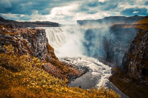
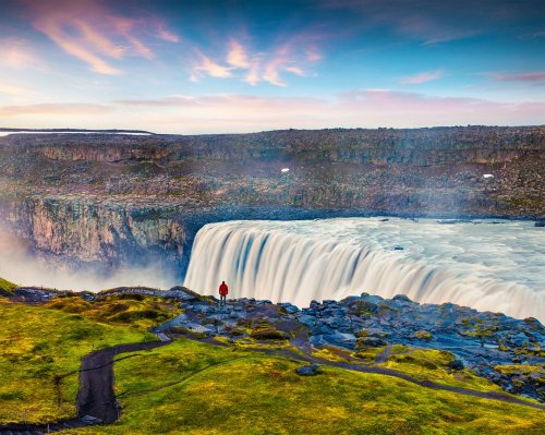
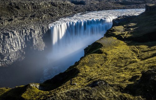
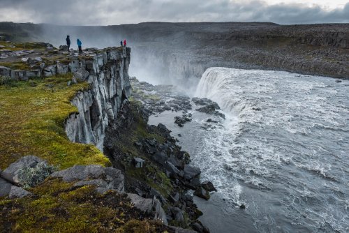
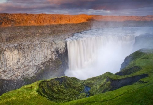
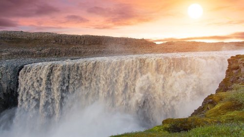
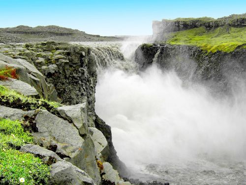
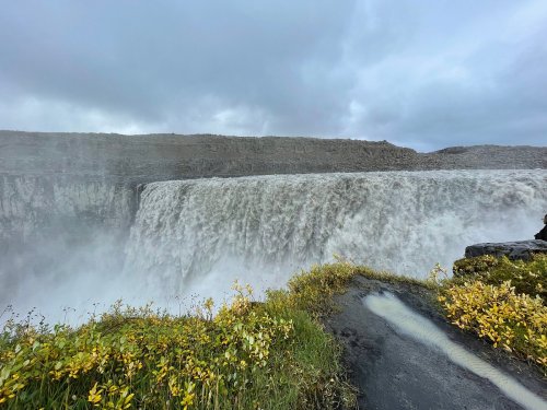
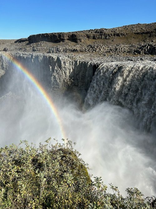
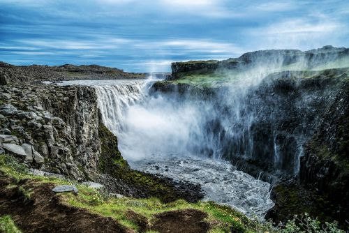
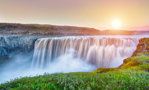
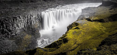
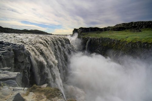
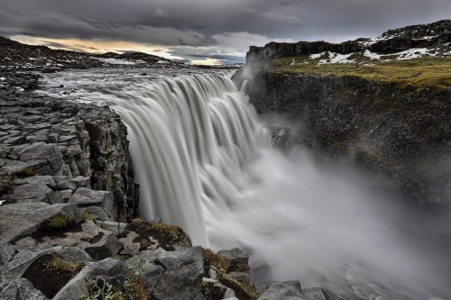
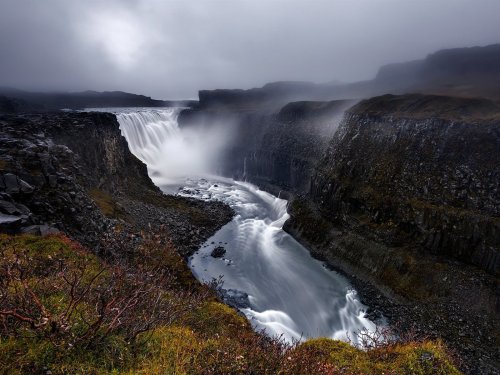
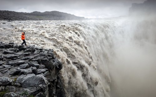
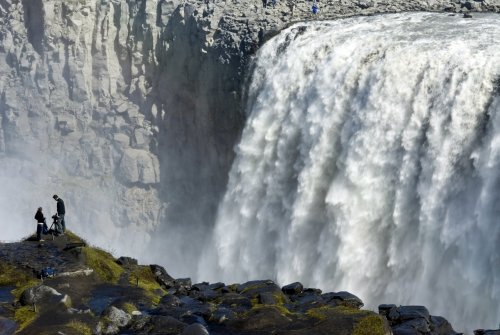


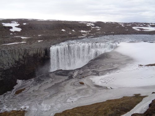
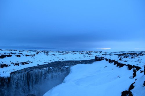
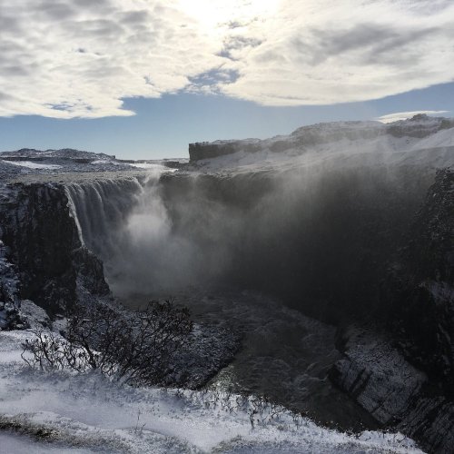
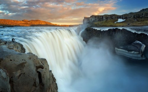
Деттифосс самый мощный водопад Исландии и Европы, его называют «европейской Ниагарой».При ширине около 100 метров этот водопад низвергается с высоты в 44 метра. Во время паводков количество воды в водопаде может вырости в 3-4 раза и в пиковые моменты составляет до 600 м3/секунду! Кстати, в переводе с исландского Деттифосс значит Бурлящий водопад, гул его слышен на многие мили вокруг.
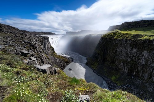
Водопад находится в северо-восточной части острова, в Национальном парке Исландии Йёкульсаурглювур и расположенн на крупной реке Йёкюльсау-ау-Фьёдлюм. Ледниковое питание реки Йёкюльсау-ау-Фьёдлюм обуславливает не совсем обычный для исландских рек буро-коричневый цвет воды, срывающейся с уступов Деттифосс. Путь к живописному творению природы лежит сквозь пустынную местность, покрытую множеством дюн черного песка.Единственным исключением является зеленый оазис на склоне холма на западном берегу, куда попадают брызги от водопада, увлажняя почву. Однако на восточном берегу совершенно иная картина. При определенном направлении ветра вы можете промокнуть до нитки от брызг. Из-за густого облака брызг дно водопада не просматривается, однако хорошо видны потрясающие базальтовые колонны, которые встречаются на всем пути с обеих сторон реки.
Однако не только своей мощью и суровой красотой известен водопад Деттифосс, но и своим участием в кинематографе - именно этот водопад "сыграл" роль в фильме Ридли Скотта "Прометей". По версии Скотта именно тут зародилась жизнь на Земле.
Dettifoss is the most powerful waterfall in Iceland and Europe, it is called the “European Niagara”. With a width of about 100 meters, this waterfall falls from a height of 44 meters. During floods, the amount of water in the waterfall can increase 3-4 times and at peak moments it reaches up to 600 m3/second! By the way, in Icelandic Dettifoss means Raging Waterfall; its roar can be heard for many miles around.
The waterfall is located in the northeastern part of the island, in the Jökulsárglúvur National Park of Iceland and is located on the large river Jökulsau au Fjödlum. The glacial feeding of the Jökulsau au Fjödlum River causes the brown-brown color of the water falling from the Dettifoss ledges, which is unusual for Icelandic rivers. The path to the picturesque creation of nature lies through a desert area covered with many dunes of black sand. The only exception is a green oasis on the hillside on the western shore, where spray from a waterfall falls, moistening the soil. However, on the eastern shore the picture is completely different. In certain wind directions, you can get wet to the skin from the spray. Due to the thick cloud of spray, the bottom of the waterfall is not visible, but the stunning basalt columns that occur along the entire path on both sides of the river are clearly visible.
However, the Dettifoss waterfall is known not only for its power and harsh beauty, but also for its participation in cinema - it was this waterfall that “played” a role in Ridley Scott’s film “Prometheus”. According to Scott, this is where life on Earth originated.
Источник://t.me/roundtravel,/scandica.ru/iceland/sights1/vodopad_dettifoss_dettifoss/,//www.andreev.org/travel-photos/iceland-dettifoss . html,//www.tripadvisor.ru/Attraction_Review-g315845-d1912449-Reviews-Dettifoss_Waterfall-Lake_Myvatn_Northeast_Region.html, /scandica.ru/iceland/sights1/vodopad_dettifoss_dettifoss/,/vislandii.com/attractions/waterfall/100-dettifoss waterfall, //www.vodopads.ru / blog /vodopad_dettifoss_dettifoss/2012-10-26-33, //www.equatorial . by/content/vodopad-dettifoss-dettifoss,/priroda.club/vodopady/8358-vodopad-dettifoss-islandija-56-foto.html.

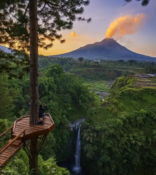
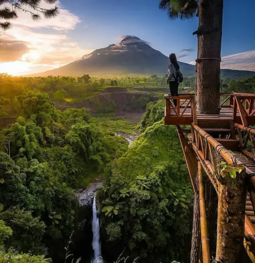


Водопад Кедунг Каян — это скрытая жемчужина, расположенная на территории Национального парка горы Мерапи. Эта очень интересная туристическая достопримечательность, находится на границе районов Магеланг и Бойолали, Центральная Ява, Индонезия. Водопад Кедунг Каян берет свое начало исключительно из источника на горе Мербабу,и расположен на высоте примерно 1200 метров над уровнем моря.Водопад Кедунг Каян имеет высоту около 40 метров, он очень мощный,объем потока воды, никогда не уменьшается, даже в разгар засушливого сезона. Чтобы добраться к водопаду нужно будет спуститься к руслу реки и даже в одном месте пересечь ее в брод.Красотой этого водопада можно любоваться с разных сторон. Либо сверху, сбоку или спереди.
Территория вокруг самого водопада застроена таким образом, чтобы стать туристическим местом. Вокруг есть несколько вспомогательных объектов, таких как жилье и кемпинги. Атмосфера в самой локации у водопада не слишком оживленная, поэтому вы сможете более свободно наслаждаться свежестью природы. Вода, падающая с этого водопада, впадает в небольшую каменистую речку. Можно зайти в бассейн, поиграть в воде под плеск водопада.
Kedung Kayan Falls is a hidden gem located within Mount Merapi National Park. This very interesting tourist attraction is located on the border of Magelang and Boyolali districts, Central Java, Indonesia. Kedung Kayan Falls originates exclusively from a spring on Mount Merbabu, and is located at an altitude of approximately 1200 meters above sea level. Kedung Kayan Falls has a height of about 40 meters, it is very powerful, the volume of water flow never decreases, even at the height of the dry season . To get to the waterfall, you will need to go down to the river bed and even cross it into a ford in one place. The beauty of this waterfall can be admired from different angles. Either from above, from the side or from the front.
The area around the waterfall itself has been developed in such a way as to become a tourist destination. There are several supporting facilities such as accommodation and campsites around. The atmosphere in the waterfall location itself is not too lively, so you can more freely enjoy the freshness of nature. The water falling from this waterfall flows into a small rocky river. You can go into the pool and play in the water while listening to the splash of the waterfall.
Источник://www.tripadvisor.ru/Attraction_Review-g6925271-d711 5 432-Reviews-Kedung_Kayang_Waterfall-Boyolali_ Central _ Java .html,//www.getyourguide.ru/air-terjun-kedung-kayang-l194646/kul-tura-i-istoriia-tc27/,/jateng.akurat.co/wisata-kuliner /1333640325 / misteri-dan-cerita-mistis-yang-ada-di-air-terjun-kedung-kayang-magelang-yang-menjadi-daya-tarik-wisata,/discoveryourindonesia . com/kedung-kayang/,/commons.wikimedia.org /wiki/ File:Kedung_ Kayang_Waterfall.jpg,/ksmtour.com/informasi/tempat-wisata/jawa-tengah/air-terjun-kedung-kayang-jawa-tengah-yang-konon-berpenunggu.html.


Каскад живописных Бадукских озер самый знаменитый туристический объект, лежит в долине р. Бадук между между грозными стенами хребтов Бадук и Хаджибей. Они расположены в охранной зоне Тебердинского заповедника, на территории Карачаево-Черкессии, в непосредственной близости от Домбая. В геологическом плане они являются молодыми (около 200 лет). Эти водоёмы - результат природных преобразований, связанных с образованием на реке крупных запруд. Эти запруды, в свою очередь, возникли из-за обвалов камней. Бадукские озера наполнены абсолютно прозрачной водой, цвет которой меняется в зависимости от погоды и времени суток. Иногда она кажется нежно-бирюзовой, а иногда – темно-фиолетовой. В озерах обитает форель, но поскольку они находятся в заповеднике, рыбалка здесь запрещена. По берегам растут сосны и березовое криволесье, но зимой лавины часто уничтожают и кустарники, и деревья.В границах заповедника, кроме водоемов, расположены ледники, скальные гряды, заливные луга и массивы лесов. Всего водоемов три:
-Первый – самый крошечный. Его диаметр всего 80 метров, а глубина не доходит и до 5 м. Вода в нем очень студеная – круглый год она не превышает отметку +5С.
-Второй водоем, находящийся на 260 м выше – несколько крупнее. Его диаметр достигает 200 метров. Бадукские озера (высота второго из них – 1987 м относительно уровня моря) располагаются одно за другим, постепенно поднимаясь в гору.
-Третье – самое огромное. Его размеры составляют 330 на 200 метров, а площадь превышает 3,5 гектара. Здесь восторженно замирают все, приехавшие на Бадукские озера – фото этих мест потрясают и завораживают. Глубина его достигает 9 метров, а вода прозрачная и чистая. В пользу последнего факта говорит то, что в Большом Бадукском издавна поселилась форель. Водоем плещется выше своих собратьев, на высоте 1 990 метров. В этом озере нередко купаются туристы – хотя оно довольно прохладное, но невероятно чистое. Здесь в конце весны и в начале лета цветет белый рододендрон.
По словам большинства туристов, в эти места хорошо приезжать золотой осенью, с середины сентября и до конца октября. В это время сочная зелень окрашивается в яркие цвета, что отражается в лазурной глади озерных вод – потрясающее зрелище. Эффектные фотографии получаются на берегах озер. Интересно запечатлеть течение Теберды с подвесного моста возле трассы и место слияния стремительных рек Бадук и Хаджибей.
The cascade of picturesque Baduk lakes, the most famous tourist attraction, lies in the valley of the river. Baduk between the formidable walls of the Baduk and Khadzhibey ridges. They are located in the protected zone of the Teberda Nature Reserve, on the territory of Karachay-Cherkessia, in close proximity to Dombay.
Geologically, they are young (about 200 years old). These reservoirs are the result of natural transformations associated with the formation of large dams on the river. These dams, in turn, arose due to rock falls. The Baduk lakes are filled with absolutely clear water, the color of which changes depending on the weather and time of day. Sometimes it appears soft turquoise, and sometimes dark purple. The lakes are home to trout, but since they are located in a nature reserve, fishing is prohibited here. Pine trees and crooked birch forests grow along the banks, but in winter avalanches often destroy both shrubs and trees. Within the boundaries of the reserve, in addition to reservoirs, there are glaciers, rocky ridges, water meadows and forests. There are three reservoirs in total:
-The first one is the tiniest. Its diameter is only 80 meters, and its depth does not even reach 5 m. The water in it is very cold - all year round it does not exceed +5C.
-The second reservoir, located 260 m higher, is somewhat larger. Its diameter reaches 200 meters. The Baduk lakes (the height of the second of them is 1987 m relative to sea level) are located one after another, gradually rising up the mountain.
- The third is the largest. Its dimensions are 330 by 200 meters and its area exceeds 3.5 hectares. Here everyone who comes to the Baduk Lakes freezes with delight - the photos of these places are stunning and mesmerizing. Its depth reaches 9 meters, and the water is clear and clean. The latter fact is supported by the fact that trout have long settled in Bolshoy Baduksky. The reservoir splashes higher than its fellows, at an altitude of 1,990 meters. Tourists often swim in this lake - although it is quite cool, it is incredibly clean.White rhododendron blooms here in late spring and early summer.
According to most tourists, it is good to come to these places in the golden autumn, from mid-September to the end of October. At this time, the lush greenery turns into bright colors, which is reflected in the azure surface of the lake waters - a stunning sight. Spectacular photographs are taken on the shores of lakes.It is interesting to capture the flow of the Teberda from the suspension bridge near the highway and the confluence of the fast-moving rivers Baduk and Khadzhibey.
Источник://t.me/divo_planeta,/pikabu.ru/story/dombay_badukskie_ozera_7787251,//treepics.ru/16876-badukskie-ozera-zimoi,//dombay. krymea.ru /badukskie-ozera/,/turisticum.ru/baduki/,//kukarta.ru / badukskie-ozera,/bolshayastrana.com /dostoprimechatelnosti / dombaj/badukskie-ozyora-60,/kukarta.ru/badukskie-ozera/, club-voshod.com/info/pohodnoe_info/dostoprimechatelnosti/dombay/dombay_badukskie_ozera/,/bolshayastrana.com/dostoprimechatelnosti/dombaj/badukskie-ozyora-60,/www.kp.ru/russia /dombaj/mesta /badukskie-ozera/.
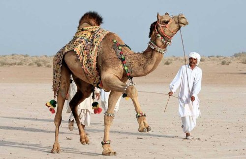
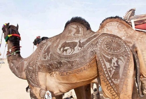
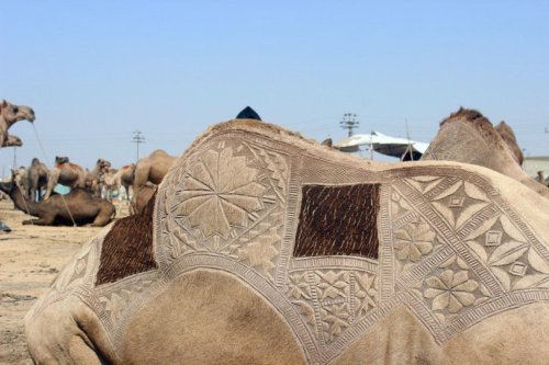
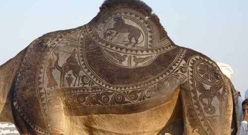
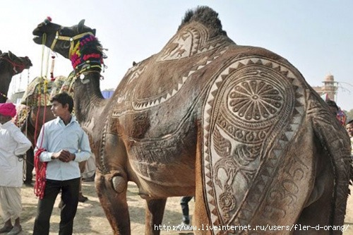
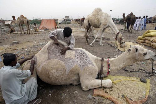
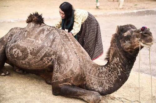
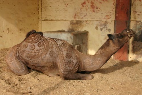
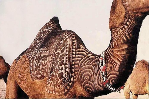
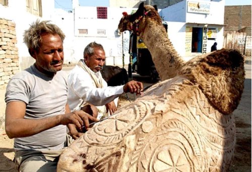
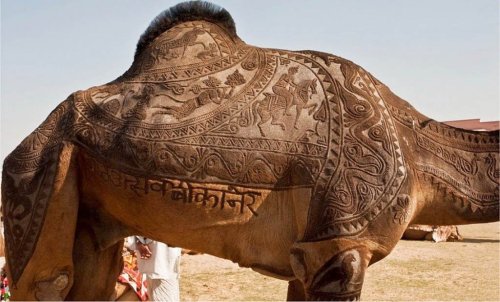
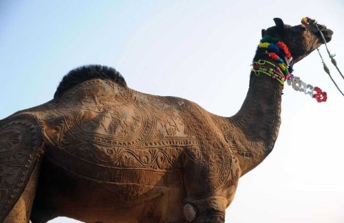
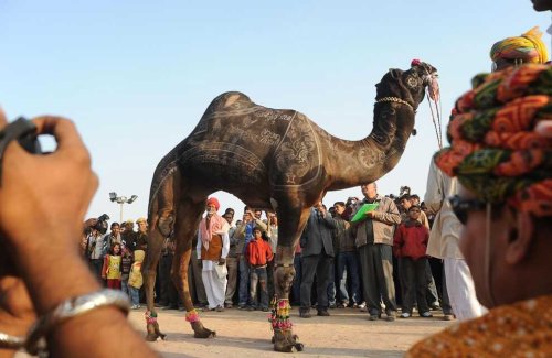
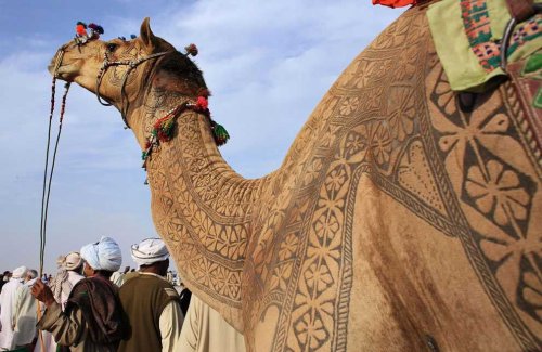
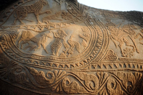
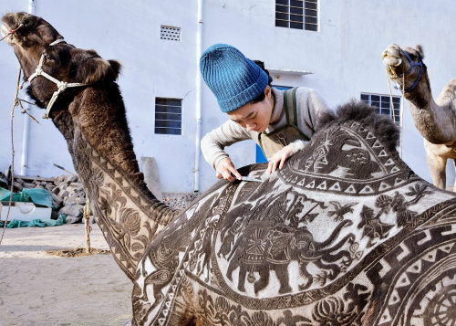
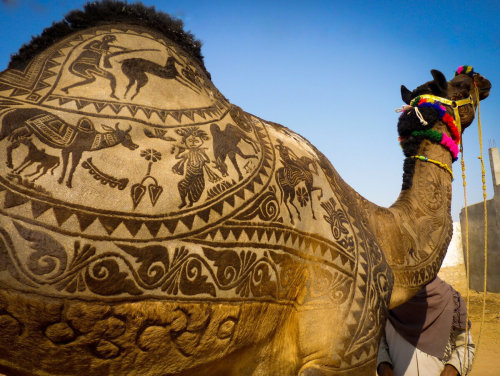
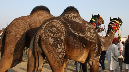
В Индии фестиваль верблюдов – одно из самых красивых и запоминающихся событий в стране. Проходит фестиваль в индийском городе Биканер в штате Раджастан. Биканер находится в пустыне Тар и знаменит тем, что именно в нем расположена единственная в Индии ферма верблюдов.
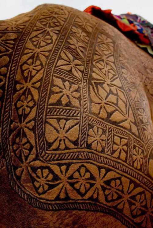
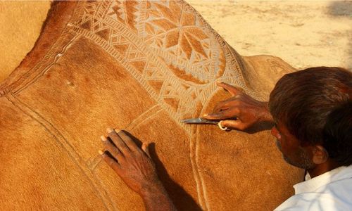
Изюминка этого праздника - оригинальный верблюжий карвинг. Карвинг по шерсти (так называется художественная стрижка верблюдов) - это искусство, которое требует не только высокого уровня профессионализма и определенных навыков, но и нескончаемого терпения. Верблюдов стригут особым образом, создавая на теле изысканные узоры. На создание такой оригинальной прически хозяину животного нужно около трех лет. Первые два года, пока шерсть верблюда отрастает, ее только подравнивают и подготавливают. А на третий год, когда шерсть вырастает нужной длины, перед началом фестиваля ее аккуратно выстригают в виде различных орнаментов на спине, боках и шее верблюда. Причем делается все это только вручную, с помощью обыкновенных ножниц.
Некоторые счастливые владельцы не останавливаются и на этом – они подкрашивают выборочно кончики волос в более темный цвет, чтобы рисунок выглядел эффектнее и рельефнее. Так получается настоящее произведение искусства, живой ковер с узорами удивительной красоты. Для конкурса красоты верблюдов также украшают различными красочными аксессуарами.
In India, the camel festival is one of the most beautiful and memorable events in the country. The festival is taking place in the Indian city of Bikaner in the state of Rajasthan. Bikaner is located in the Thar desert and is famous for the fact that it is the only camel farm in India.
The highlight of this holiday is the original camel carving. Wool carving (the so-called artistic camel shearing) is an art that requires not only a high level of professionalism and certain skills, but also endless patience. Camels are sheared in a special way, creating exquisite patterns on the body. It takes about three years for the owner of the animal to create such an original hairstyle. For the first two years, while the camel's hair grows, it is only trimmed and prepared. And in the third year, when the wool grows to the desired length, before the start of the festival it is carefully cut in the form of various ornaments on the camel's back, sides and neck. Moreover, all this is done only manually, using ordinary scissors.
Some happy owners do not stop there either – they selectively tint the ends of their hair in a darker color so that the pattern looks more spectacular and more relief. So it turns out to be a real work of art, a living carpet with patterns of amazing beauty. Camels are also decorated with various colorful accessories for the beauty contest.
Источник:/ekabu.ru/160021-verblyuzhiy-bodi-art-18-foto.html, /astv.ru/club/blog/utro/6jXTE7Xkd02AQEOfZY-8Fg, /multiurok.ru / blog/nieobychnyi-vid-iskusstva-vierbliuzhii-bodiart.html, //dzen.ru /a /YndBAXlNcTNWFXvW.
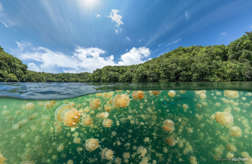
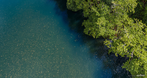
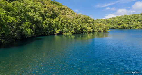
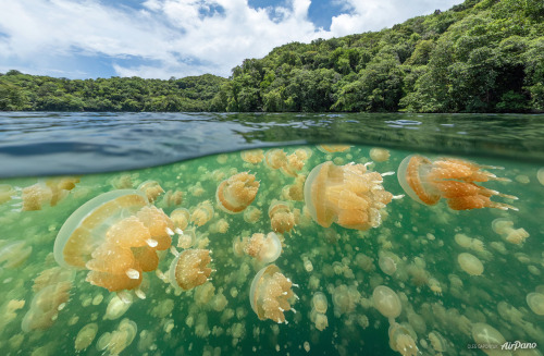
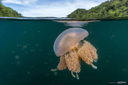
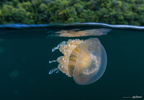
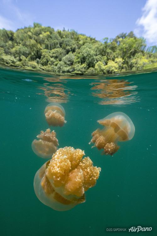
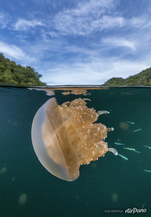
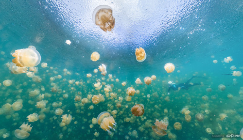
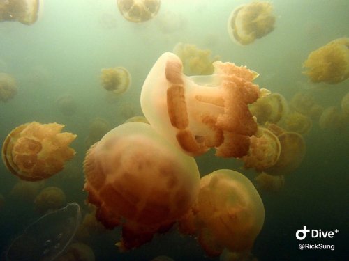
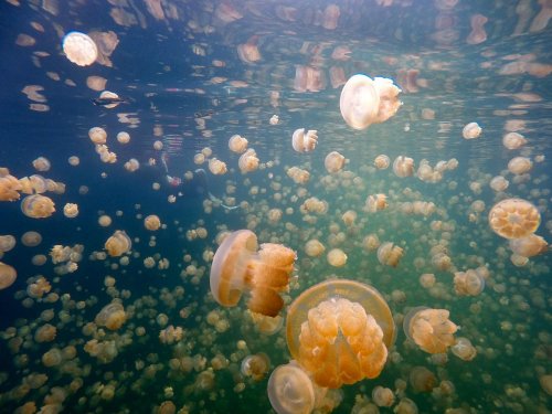
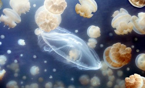
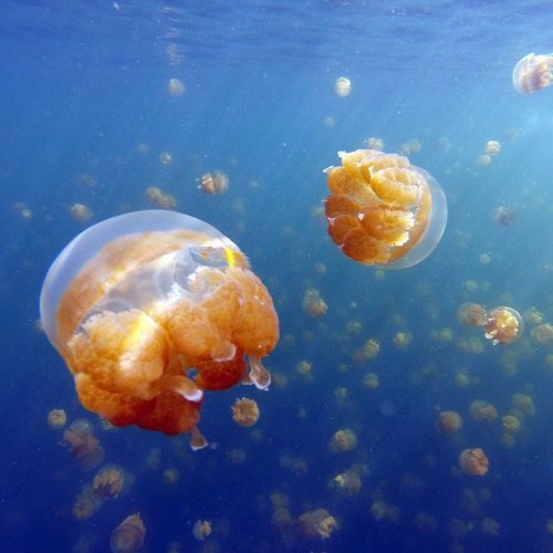
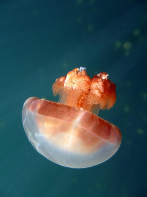
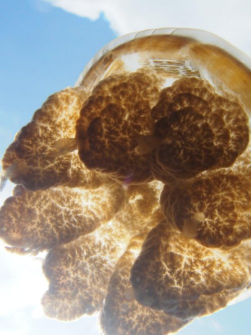
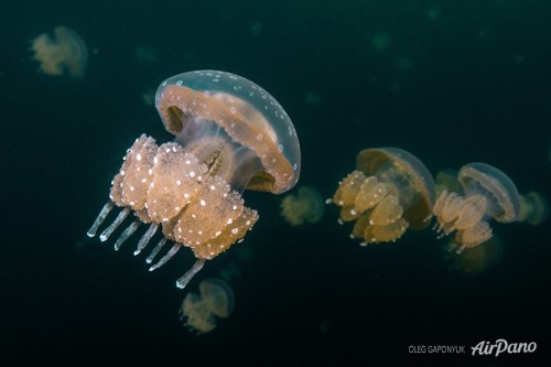
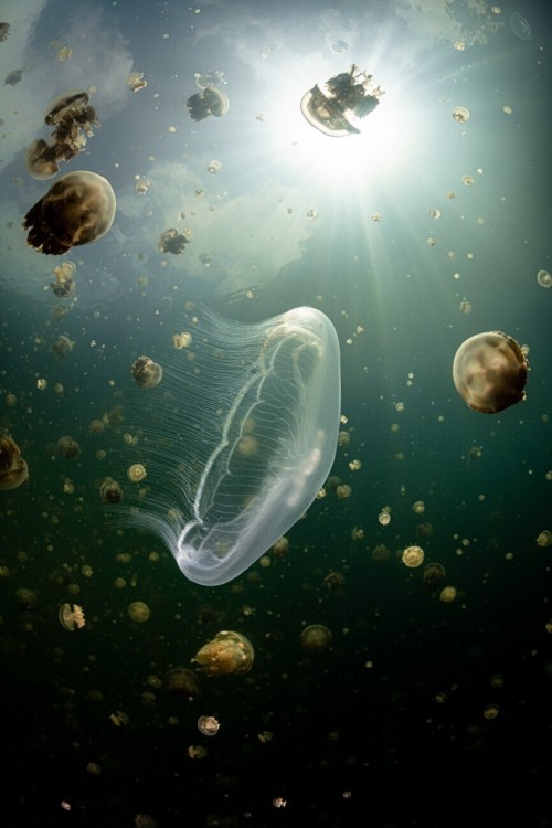
Озеро Медуз — озеро в архипелаге Скалистые острова (Палау). Озеро расположено на востоке острова Эйл-Малк, в более чем 20 км к юго-востоку от Корора. Этот естественный слабо-солёный водоем имеет глубину до 50 метров и размеры всего 460 м на 160 м, он сообщается с расположенным примерно в 200 метрах Тихим океаном через трещины и поры в горной породе.
Озеро Медуз разделено на два слоя — бескислородный и с большим содержанием кислорода. Первый, нижний слой (приблизительно от глубины 15 метров и до дна) обладает высокой концентрацией аммиака и фосфатов, чем опасен для дайверов, которые могут получить отравление через кожу. В этом слое живут только бактерии. Зато другой слой, насыщенный кислородом (примерно до глубины 15 м), населяют разнообразные микроорганизмы, несколько видов рыб и веслоногих ракообразных и, конечно же, медузы.
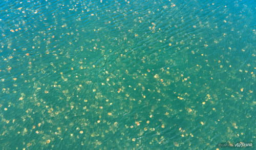
Образованное движением земной коры более 12 000 лет назад озеро известно своей обособленной популяцией двух видов сцифоидных — золотая медуза (Mastigias papua) и лунная медуза (Aurelia). За время, проведенное вдали от моря, живущие здесь золотисто-оранжевые медузы эволюционировали и утратили свою способность жалить. Весь день они следуют за солнцем, перемещаясь по глади озера, а к ночи опускаются на дно, где подпитываются водорослями. Лунные медузы питаются веслоногими ракообразными, для чего ночью поднимаются на поверхность озера. Считается,что общая численность медуз, обитающих в этом необычном озере, достигает двух миллионов особей. Количество медуз так велико, что их массу легко можно заметить, даже находясь в самолете. Золотая медуза имеет огромное численное превосходство над лунной.
Кроме того, в озере Медуз не разрешено нырять с аквалангом. Воздушные пузырьки, которые образуются во время дыхания аквалангиста, попадают под купол медузы и могут привести к ее гибели. По этим причинам в озере плавают только в верхнем слое воды, используя ласты и маску. Погружение в воды этого медузового озера – удивительная возможность попасть в иной мир, оказавшись в самом центре гипнотического танца медуз.
Jellyfish Lake is a lake in the Rocky Islands archipelago (Palau). The lake is located on the east of Eil Malk Island, more than 20 km southeast of Koror. This natural, slightly saline body of water is up to 50 meters deep and measures just 460 m by 160 m, connecting to the Pacific Ocean about 200 meters away through cracks and pores in the rock.
Jellyfish Lake is divided into two layers: anoxic and highly oxygenated. The first, lower layer (from approximately a depth of 15 meters to the bottom) has a high concentration of ammonia and phosphates, which is dangerous for divers, who can become poisoned through the skin. Only bacteria live in this layer. But another layer, saturated with oxygen (to about a depth of 15 m), is inhabited by a variety of microorganisms, several species of fish and copepods and, of course, jellyfish.
Formed by the movement of the earth's crust over 12,000 years ago, the lake is known for its distinct population of two scyphoid species - the golden jellyfish (Mastigias papua) and the moon jellyfish (Aurelia). During their time away from the sea, the golden-orange jellyfish that live here have evolved and lost their ability to sting. All day they follow the sun, moving along the surface of the lake, and by night they sink to the bottom, where they feed on algae. Moon jellyfish feed on copepods, for which they rise to the surface of the lake at night. It is believed that the total number of jellyfish living in this unusual lake reaches two million individuals. The number of jellyfish is so large that their mass can be easily noticed even while on an airplane. The golden jellyfish has a huge numerical superiority over the lunar jellyfish.
Additionally, scuba diving is not allowed in Jellyfish Lake. Air bubbles that form during the scuba diver's breathing fall under the dome of the jellyfish and can lead to its death.For these reasons, people swim in the lake only in the upper layer of water, using fins and a mask. Diving into the waters of this jellyfish lake is an amazing opportunity to enter another world, finding yourself in the very center of the hypnotic dance of jellyfish.
Источник: //www.stepandstep.ru/biologiya/ozero-meduz, //cameralabs.org/aeon/fotokonkurs-siena-international-awards /foto/ 46069-pooshchritelnaya-premiya-v-kategorii-krasota-prirody-2021-ozero-meduz-avtor-khenli-spajers,//www.cawater-info.net /all_about _water/?p=14456,dzen.ru/a/XbytncBccQCufY29, //topwonders .ru / palau/ozero-meduz-na-palau.html,omyworld.ru/9937,//www. stepandstep.ru/biologiya/ozero-meduz/,/www.airpano.ru /360article / jellyfish-lake-palau/,/www.tripadvisor.ru/Attraction_Review-g294136-d795830-Reviews-Jellyfish_Lake-Koror_Koror_Island.html.