
197 posts
(Milford Sound, (Piopiotahi)) , . , , 10-12 . .


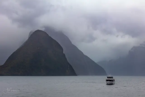
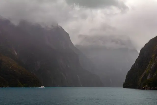


Милфорд Саунд (Milford Sound, маорийское название — Пиопиотахи (Piopiotahi)) – самый знаменитый фьорд в Новой Зеландии, известный на весь мир своей первозданной красотой. Милфорд Саунд, как и фьорды Северного полушария, сформировался в результате деятельности ледника 10-12 тысяч лет назад. Знаменитый английский путешественник и писатель Редьярд Киплинг побывал однажды на берегах Милфорд Саунд и под впечатлением увиденного назвал этот фьорд восьмым чудом света.
Милфорд Саунд – это вытянутый залив с высокими скалистыми берегами шириной около 3 км, который вдается в сушу на целых 16 км, а максимальная его глубина 512 м. Со всех сторон он окружен горными вершинами, увенчанные вечными снегами, высотой более 1,5 км. Нетронутые человеком густые влажные леса растут здесь практически на отвесных скалах.
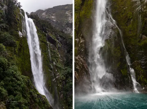
Милфорд Саунд - одно из самых влажных мест на Земле, здесь за год выпадает до 7000 мм осадков. Дождь идет каждый день и это сказывается на характере леса - гигантские деревья покрыты мхом и лианами, здесь растут лишайники и папоротники, лес очень влажный. Туристы могут рассчитывать на солнце в течение нескольких часов ближе к полудню, но во второй половине дня их наверняка настигнет ливень.
Интересный факт — В дождливые и бурные дни можно увидеть потрясающий природный феномен. Водопады, которые падают вверх. Это явление вызвано географическими особенностями Милфорд Саунда. При встрече с утесом сильный ветер часто поднимается вверх, и обычные водопады, попадая в поток воздуха, кардинально меняют свое направление.
Воды Милфорд Саунд населяет множество тюленей, пингвинов и дельфинов. Исследовательская станция Милфорд Дип позволяет ученым и туристам «заглянуть» в подводный мир. При таком изобилии мелких птиц невозможно обойтись без хищников: в глубине фьорда рассекают толщу воды многочисленные акулы. Также здесь можно увидеть уникальные коралловые рифы, в том числе и самые редкие виды - черные кораллы. Вода в Милфорд Саунд настолько прозрачная, что дно видно даже в самых глубоких местах, если, конечно, его не заслоняют густые водоросли.
Milford Sound (Maori name - Piopiotahi) is the most famous fjord in New Zealand, known throughout the world for its pristine beauty. Milford Sound, like the fjords of the Northern Hemisphere, was formed as a result of glacier activity 10-12 thousand years ago. The famous English traveler and writer Rudyard Kipling once visited the shores of Milford Sound and, impressed by what he saw, called this fjord the eighth wonder of the world.
Milford Sound is an elongated bay with high rocky shores about 3 km wide, which juts into the land for as much as 16 km, and its maximum depth is 512 m. On all sides it is surrounded by mountain peaks, crowned with eternal snow, more than 1.5 km high. Dense rainforests untouched by man grow here almost on sheer cliffs.
Milford Sound is one of the wettest places on Earth, with up to 7,000 mm of rainfall per year. It rains every day and this affects the character of the forest - giant trees are covered with moss and vines, lichens and ferns grow here, the forest is very humid. Tourists can expect sun for a few hours closer to midday, but in the afternoon they will probably be overtaken by a downpour.
Interesting fact - On rainy and stormy days, you can see an amazing natural phenomenon. Waterfalls that fall upwards. This phenomenon is caused by the geographical features of Milford Sound. When meeting a cliff, a strong wind often rises upwards, and ordinary waterfalls, getting into the air flow, radically change their direction.
The waters of Milford Sound are inhabited by many seals, penguins and dolphins. The Milford Deep research station allows scientists and tourists to "look" into the underwater world. With such an abundance of small birds, it is impossible to do without predators: in the depths of the fjord, numerous sharks cut through the water. Here you can also see unique coral reefs, including the rarest species - black corals. The water in Milford Sound is so transparent that the bottom is visible even in the deepest places, unless, of course, it is obscured by thick algae.
Источник: //mirsg.ru/ru/pages/milford-sound,//cattur.ru/australia-and-oceania/new-zealand/milford-saund.html,/australiantravelclub.ru /articles/milford_saund_i_paryashchie_vodopady.htm,/sunsetobsession.com/ru/milford-sound/,/mirsg.ru/ru/pages/milford-sound, /varlamov.ru/1250158.html,//wikiway.com/novaya-zelandiya/milford-saund/,vk.com/@greenfieldworld-novaya-zelandiya-fordlend-milford-saund.
-
 futurequeensmusic liked this · 8 months ago
 -
 angelayasmim liked this · 8 months ago
 -
 leontinrau liked this · 8 months ago
 -
 asahi-yamane-art liked this · 8 months ago
 -
 htn-11-11 liked this · 8 months ago
 -
 peace0fmind reblogged this · 8 months ago
 -
 35-erdogan-35 liked this · 8 months ago
 -
 uniquestarsworld liked this · 8 months ago
 -
 drewnozerca liked this · 8 months ago
 -
 lovethemfiercely liked this · 8 months ago
 -
 wisent15 liked this · 8 months ago
 -
 aria-diary liked this · 9 months ago
 -
 autisticflapper liked this · 9 months ago
 -
 musicandgallery liked this · 9 months ago
 -
 wolfsoullight liked this · 9 months ago
 -
 alanbiya reblogged this · 9 months ago
 -
alanbiya liked this · 9 months ago
-
 king-of-roses-world liked this · 9 months ago
 -
 ludmila199 liked this · 9 months ago
 -
 j-trofi liked this · 9 months ago
 -
 niraistyles liked this · 9 months ago
 -
 thelostdreamsthings liked this · 9 months ago
 -
 alpaslangokdemir reblogged this · 9 months ago
 -
 huseyinoktensblog liked this · 9 months ago
 -
dighowtheydothat reblogged this · 9 months ago
-
dighowtheydothat liked this · 9 months ago
-
 b3gr8w0n reblogged this · 9 months ago
 -
 stars-and-everythang-in-between reblogged this · 9 months ago
 -
 erabesteira liked this · 9 months ago
 -
b3gr8w0n liked this · 9 months ago
-
 genunchiilumii liked this · 9 months ago
 -
 ottori48 liked this · 9 months ago
 -
 vanatcha liked this · 9 months ago
 -
 wembomusic liked this · 9 months ago
 -
 marley8world liked this · 9 months ago
 -
 mrsucedaneo liked this · 9 months ago
 -
 osmankhtab93 liked this · 9 months ago
 -
 1-125sec-f8-10feet liked this · 9 months ago
 -
 kroner26 liked this · 9 months ago
 -
 phegos reblogged this · 9 months ago
 -
 layer13 reblogged this · 9 months ago
 -
 famousinuniverse liked this · 9 months ago
 -
 cptn-catastrophic reblogged this · 9 months ago
 -
 vivelafranceblog liked this · 9 months ago
 -
 naser1963 liked this · 9 months ago
 -
 seelensblog liked this · 9 months ago
More Posts from Vestaignis


Азорские острова - край вулканов и гортензий.
Название островов, скорее всего, происходит от устаревшего португальского слова «azures», что буквально означает «голубые». Синего цвета и его оттенков здесь и впрямь много, особенно в мае и начале июня, когда острова покрываются цветущими гортензиями. Жители острова Флорес даже ходят на работу через поля диких гортензий. Азорские острова – это рай для тех, кто любит природу.
The Azores are a land of volcanoes and hydrangeas.
The name of the islands most likely comes from the obsolete Portuguese word "azures", which literally means "blue". There really is a lot of blue and its shades here, especially in May and early June, when the islands are covered with blooming hydrangeas. Residents of the island of Flores even walk to work through fields of wild hydrangeas. The Azores are a paradise for those who love nature.
Источник://t.me/krasivye_mesta_turizm, /ybis.ru/ostrova/azorskie-ostrova-gortenzii,/miss-hohotyn007.livejournal.com /1110530.html, /oir.mobi/704214-azorskie-ostrova-gortenzii.html,/ybis.ru/ostrova/ azorskie-ostrova-gortenzii,/ru.pinterest.com/pin/656047870752312063/, /aaavolkov.livejournal.com/8175.html,klau.club/974-azorskie-ostrova.


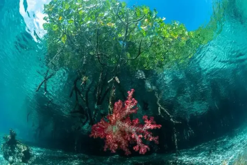
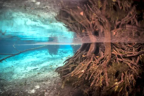
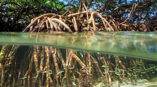
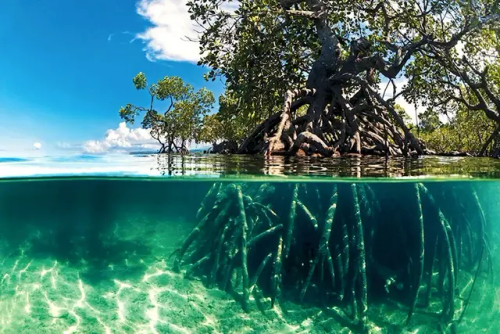
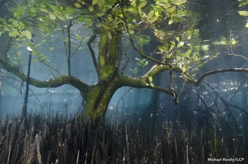


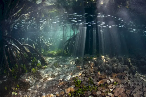
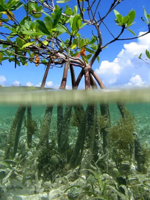

Подводные обитатели мангрового леса. Underwater inhabitants of the mangrove forest.
Источник:/yazhevika.ru/priroda/mangrovyy-les-pod-vodoy, //pikabu.ru/tag/%D0%9C%D0%B0%D0%BD%D0%B3%D1%80%D0%BE%D0%B2%D0%BE%D0%B5%20%D0%B4%D0%B5%D1%80%D0%B5%D0%B2%D0%BE/hot,/oclo.ru/mangrovyy-les-pod-vodoy/, /dzen.ru/a/ZqzDdiMaR2FxYlVJ,//fishki.net/4680605-pobediteli-konkursa-mangrove-photography-awards-2024.html,/dzen.ru/a/ Y3CphsYT93qWfxM7?partner_user_id=%5Bobject%20Object%5D, haritonoff.livejournal.com/338963.html.


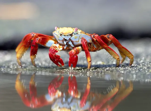
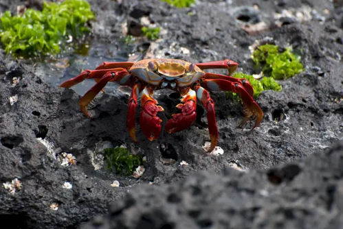


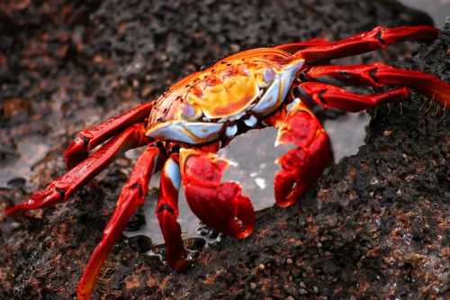


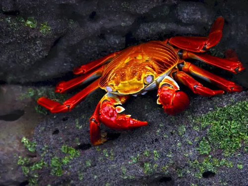

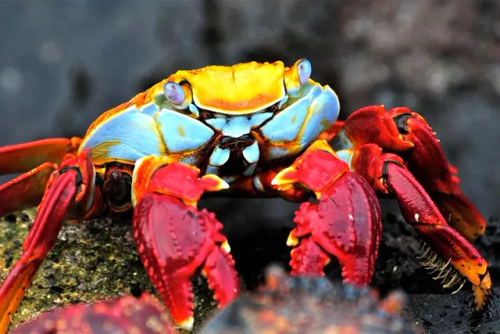
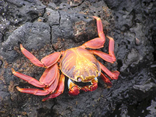
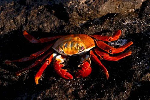


Красный скальный краб (лат. Grapsus grapsus) или «Sally Lightfoot Crab» – десятиногое ракообразное из семейства Grapsidae. Салли Лайтфут — это небольшой, с достигающим 8 сантиметров панцирем, вертикально сплюснутый краб с общей окраской от коричневого до оливково-коричневого цвета и полосами от коричневого до желтого или оранжевого цвета на ногах. Детёныши красного скального краба окрашены в чёрный цвет.
Вид был впервые описан Карлом Линнеем ещё в 1758 году, но до 1990 года этих крабов относили к виду Grapsus adscensionis, обитающему в восточной части Атлантического океана. Животное обитает на тихоокеанском побережье и Центральной Америки, Мексики и Южной Америки до северного Перу; многочисленны на Галапагосских островах. Кроме того, эти крабы водятся в Атлантическом океане на отдаленной группе островов Сан-Педру-и-Сан-Паулу.
Красный скальный краб отличается большой проворностью и ловкостью, поэтому его очень трудно поймать. Он очень резво перемещается по твердой поверхности и может бегать по почти вертикальным утесам. Салли Лайтфут обладает уникальной способностью плотно всем телом прижиматься к скалам с такой силой, что его не может оторвать даже сильный прибой. Нередко его можно увидеть отдыхающим на камнях вместе с морскими игуанами. Иногда представители данного вида помогают ящерицам избавиться от поселившихся на их коже паразитов.
Красные крабы бурно реагируют на приближение любых хищников. При малейшей опасности они спасаются бегством. Они постоянно резко меняют направление бега, что в большинстве случаев сбивает преследователей с толку.Животное также отличается умением быстро регенерировать утраченные конечности, оставив их на съедение хищникам. Днем ракообразные прячутся в скальных расщелинах или норах. Во время ночного отлива они разгуливают по обнажившемуся дну в поисках пищи. Питаются Grapsus grapsus водорослями и падалью, выброшенными на берег морем. В целом они ведут полуводный образ жизни.
Старые особи живут в гордом одиночестве, а молодь предпочитает собираться порой весьма многочисленными группами.
The red rock crab (lat. Grapsus grapsus) or "Sally Lightfoot Crab" is a decapod crustacean of the family Grapsidae. Sally Lightfoot is a small, with a shell reaching 8 centimeters, vertically flattened crab with a general coloration from brown to olive-brown and stripes from brown to yellow or orange on the legs. The young of the red rock crab are colored black.
The species was first described by Carl Linnaeus in 1758, but until 1990 these crabs were classified as the species Grapsus adscensionis, which lives in the eastern part of the Atlantic Ocean. The animal lives on the Pacific coast and Central America, Mexico and South America to northern Peru; numerous on the Galapagos Islands. In addition, these crabs are found in the Atlantic Ocean on the remote group of islands of Sao Pedro and Sao Paulo.
The red rock crab is very agile and dexterous, so it is very difficult to catch. It moves very quickly on a hard surface and can run along almost vertical cliffs. Sally Lightfoot has a unique ability to press its entire body tightly to the rocks with such force that even a strong surf cannot tear it away. It can often be seen resting on the rocks with marine iguanas. Sometimes representatives of this species help lizards get rid of parasites that have settled on their skin.
Red crabs react violently to the approach of any predators. At the slightest danger, they flee. They constantly sharply change the direction of their run, which in most cases confuses their pursuers. The animal is also distinguished by the ability to quickly regenerate lost limbs, leaving them to be eaten by predators. During the day, crustaceans hide in rock crevices or burrows. During the night low tide, they walk along the exposed bottom in search of food. Grapsus grapsus feed on algae and carrion washed up on the shore by the sea. In general, they lead a semi-aquatic lifestyle.
Old individuals live in proud solitude, and young ones prefer to gather in sometimes very large groups.
Источник:/t.me/+E4YBiErj0A8wOGUy,/zooclub.org.ua/kraby/krasnyj-skalnyj-krab.html, ://ru.wikipedia.org/wiki/Grapsus_grapsus, //www.lookphotos.com/en/images/70133765-Sally-Lightfoot-Crab-Grapsus-grapsus-Galapagos-Islands-Ecuador, /sotni.ru/kraby-krasivye-kartinki/.


Казино Констанцы.
История казино началась в 1880 году, вскоре после возвращения Добруджанского региона Румынии(тогда оно было деревянным). В 1889 году вследствие сильной грозы, большая часть здания была уничтожена. А в 1890 году началось новое строительство Казино, однако, место расположения было немного изменено. В 1903 году деревянный павильон был признан устаревшим и не отвечающим запросам растущего города.
Строительство каменного казино началось в 1904 году. Однако, первый подрядчик работал слишком медленно, и проект здания передали французскому архитектору Даниэлю Ренару. Тот отказался от румынского традиционного стиля и занялся смешением модных в этот момент стилей. 15 августа 1910 года оно было торжественно открыто в присутствии принца Фердинанда.
Здание выполнено в архитектурном стиле "Арт Нуво". В здании были бальный зал (благодаря чему в здании могли проводиться балы, организованные властями муниципалитета), два читальных зала, две игровые комнаты и терраса у моря. Здесь в 1914 году встречали семью русского императора – одну из его дочерей(Ольгу) сватали за румынского принца. Казино работало в режиме 24/7, было хорошо охраняемо и сюда было практически невозможно попасть без разрешения. Во время первой и второй Мировых войн здание служило как госпиталь. К сожалению, оно подверглось сильным бомбовым ударам.
В советское время Казино было восстановлено и использовалось для проведения заседаний местного совета. В конце 80х было решено вернуть зданию первоначальное предназначение и переоборудовать его обратно в казино. Последний капитальный ремонт здесь был в 1988 году. Поддержание инфраструктуры казино в последние годы стало слишком дорогим, и в 1990 году здание было закрыто. Сейчас некогда великолепное здание с колоннами, мрамором и лепниной заброшено. На его восстановление нужны большие деньги, которых, к сожалению, власти Румынии пока не нашли. Но это не мешает туристам приезжать полюбоваться роскошным дворцом.
Constanta Casino.
The history of the casino began in 1880, shortly after the return of the Dobrogea region to Romania (at that time it was wooden). In 1889, due to a strong thunderstorm, most of the building was destroyed. And in 1890, a new construction of the Casino began, however, the location was slightly changed. In 1903, the wooden pavilion was considered outdated and did not meet the needs of the growing city.
The construction of the stone casino began in 1904. However, the first contractor worked too slowly, and the design of the building was given to the French architect Daniel Renard. He abandoned the traditional Romanian style and began to mix the styles that were fashionable at that time. On August 15, 1910, it was solemnly opened in the presence of Prince Ferdinand.
The building is made in the architectural style of "Art Nouveau". The building had a ballroom (which allowed the building to host balls organized by the municipal authorities), two reading rooms, two game rooms and a terrace by the sea. In 1914, the family of the Russian emperor was met here - one of his daughters (Olga) was wooed by a Romanian prince. The casino was open 24/7, was well guarded and it was almost impossible to get in without permission. During the First and Second World Wars, the building served as a hospital. Unfortunately, it was heavily bombed.
During the Soviet era, the Casino was restored and used for meetings of the local council. In the late 80s, it was decided to return the building to its original purpose and convert it back into a casino. The last major renovation was in 1988. Maintaining the casino infrastructure in recent years has become too expensive, and in 1990 the building was closed. Now the once magnificent building with columns, marble and stucco is abandoned. Its restoration requires a lot of money, which, unfortunately, the Romanian authorities have not yet found. But this does not stop tourists from coming to admire the luxurious palace.
Источник://urban3p.ru/object24142,/profhobby.ru/wallpaper/2038-009251,planetofhotels.com/guide/ru/rumyniya/konstanca,/www.blackseanews.net/read/52468,/account.travel/place/casino-constanta.html, //vk.com/wall-134187275_1627,/fishki.net/1586431-zabroshennoe-kazino-v-rumynii.html,://fotorelax.ru/zabroshennoe-kazino-na-beregu-chernogo-morya/.


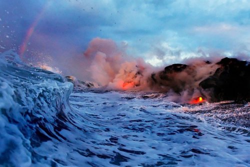


Извержение вулкана Килауэа: встреча двух стихий.
Вулкан Килауэа находится на Большом острове Гавайского архипелага и занимает почти 14% его территории.Килауэа - самый молодой из наземных гавайских вулканов (США) и один из самых активных действующих вулканов на Земле. Высота Килауэа - 1247 метров над уровнем моря, его основание уходит на дно Тихого океана на глубину около 5 км.
Последнее извержение Килауэа было в 1983 году и продолжается по настоящее время. Килауэа считается местом обитания Пеле — гавайской богини вулканов. По ее имени названы некоторые лавовые образования, например, «слезы Пеле» (маленькие капли лавы, которые студятся на воздухе и принимают фигуру слезы) и «волосы Пеле» (тонкие нити вулканического стекла обсидиана, возникающие в итоге быстрого остывания лавы при стекании в океан).
Профессиональная спортсменка Элисон Тил стала первой девушкой, решившей устроить экстремальный серфинг возле извергающегося вулкана. Бурлящие потоки лавы стекают прямо в океан, в то самое место, где и решила поплавать спортсменка. Тут стоит быть предельно осторожным и оставаться на чеку, ведь скорость, с которой движется раскаленная лава, может составлять несколько метров в секунду, а температура ее колеблется в районе 500–1200° C — этого с лихвой хватит, чтобы моментально свариться заживо.
За Килауэа круглосуточно наблюдают десятки специалистов со всего мира. На кадрах с Гавайев – огненные потоки лавы стекают со склонов вулкана прямо в Тихий океан. По утверждению ученых, при контакте раскаленной субстанции и воды брызги лавы взлетают на десятки метров. Удивительное природное явление привлекает к вулкану Килауэа туристов, которые желают увидеть столкновение стихий вживую. Однако геологи не рекомендуют приближаться к вулкану, поскольку тот может оказаться непредсказуемым.
Kilauea Volcano Eruption: A Meeting of Two Elements.
Kilauea Volcano is located on the Big Island of the Hawaiian archipelago and occupies almost 14% of its territory. Kilauea is the youngest of the Hawaiian land volcanoes (USA) and one of the most active volcanoes on Earth. Kilauea is 1,247 meters above sea level, its base goes to the bottom of the Pacific Ocean to a depth of about 5 km.
The last eruption of Kilauea was in 1983 and continues to this day. Kilauea is considered the home of Pele, the Hawaiian goddess of volcanoes. Some lava formations are named after her, for example, "Pele's tears" (small drops of lava that cool in the air and take the shape of a tear) and "Pele's hair" (thin threads of volcanic obsidian glass that appear as a result of the rapid cooling of lava as it flows into the ocean).
Professional athlete Alison Teel became the first girl to try extreme surfing near an erupting volcano. Bubbling lava flows straight into the ocean, the very place where the athlete decided to swim. Here you should be extremely careful and stay on guard, because the speed at which the hot lava moves can be several meters per second, and its temperature fluctuates around 500–1200° C — this is more than enough to instantly boil alive.
Kilauea is monitored around the clock by dozens of specialists from all over the world. In the footage from Hawaii, fiery lava flows flow from the slopes of the volcano straight into the Pacific Ocean. According to scientists, when the hot substance comes into contact with water, splashes of lava fly up tens of meters. An amazing natural phenomenon attracts tourists to the Kilauea volcano who want to see the clash of the elements live. However, geologists do not recommend approaching the volcano, as it may prove unpredictable.
Источник: /travelask.ru/blog/posts/4045-zaplyv-s-lavoy-na-gavayyah, //gsavia.com/uncategorized/gavajskie-vulkany-nacionalnyj-park.html, /ru.pinterest.com/pin/9499849187484206/,/loveopium.ru/severnaya-amerika/izrygayushhij-vulkan-kilauea.html,/masterok.livejournal.com /105805.html,//t.me/+E4YBiErj0A8wOGUy,/onznews.wdcb.ru/jul16/info_160726.html,/gorets-media.ru/news/3717.