
197 posts
.


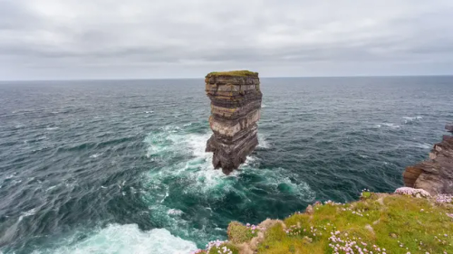


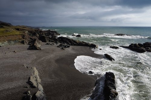
Скала Дан Брист в Ирландии.
Приблизительно в 5 км к северу от деревни Балликасл, в ирландском графстве Мейо, находится удивительный мыс под названием Даунпатрик-Хед. Возвышаясь на 38 метро выше моря, он открывает захватывающие дух виды Атлантики и высокие утесы вдоль берега. Название Даунпатрик возникло со времени, когда сам Св. Патрик основал церковь в этих местах. Вы можете все еще увидеть руины церкви, с каменным крестом наверху. Ежегодно в конце июля здесь собираются верующие, чтобы провести мессу. Во время Второй мировой войны тут был построен пост береговой охраны, который теперь используется, чтобы исследовать птиц, которые гнездятся на высоких утесах.
Отрезанная от материка и лежащая в 80 метрах от берега, находится знаменитая скала Дан Брист. Морской стек отделился от материка в 1393 под воздействием воды, и люди, живущие на утесах, были спасены с помощью веревок. Конечно же, не обошлось и без иной версии отделения скалы, которая увековечилась в древней легенде. Предания гласят, что когда-то на месте Дан Бриста жил непокорный языческий вождь, который отказался обращаться в христианство. В знак протеста самый почитаемый святой Ирландии, Патрик, ударил посохом об землю, отделив скалу вместе с вождем. Как бы то ни было, вертикальный утес является очень интересным местом – его высота составляет около 45 метров, а ширина и длина, соответственно, 63 и 23 метра. Высокие утесы мыса Даунпатрик и скалы Дан Брист, демонстрирующие многослойные разноцветные пласты пород, были сформированы более 350 миллионов лет тому назад. Эти места представляют особый интерес для орнитологов, которые наблюдают здесь за редкими птицами, гнездящимися на скалах, а в весенний период тут буйно расцветает армерия, создавая поистине фантастический пейзаж.
Dun Brist Rock in Ireland.
About 5 km north of the village of Ballycastle, in the Irish county of Mayo, lies a stunning headland called Downpatrick Head. Rising 38 metres above the sea, it offers breathtaking views of the Atlantic and the high cliffs along the coast. The name Downpatrick comes from the time when St Patrick himself founded a church here. You can still see the ruins of the church, with a stone cross on top. Every year at the end of July, the faithful gather here to celebrate mass. During the Second World War, a coastguard post was built here, which is now used to study the birds that nest on the high cliffs.
Cut off from the mainland and lying 80 metres from the shore, lies the famous Dun Brist Rock. The sea stack broke away from the mainland in 1393 under the action of the water, and the people living on the cliffs were saved with the help of ropes. Of course, there is another version of the separation of the rock, which was immortalized in an ancient legend. Legends say that once on the site of Dun Brist lived a rebellious pagan chieftain who refused to convert to Christianity. In protest, the most revered saint of Ireland, Patrick, struck the ground with his staff, separating the rock along with the chieftain.
Be that as it may, the vertical cliff is a very interesting place - its height is about 45 meters, and the width and length, respectively, are 63 and 23 meters. The high cliffs of Cape Downpatrick and the cliffs of Dun Brist, demonstrating multi-layered multi-colored rock layers, were formed more than 350 million years ago. These places are of particular interest to ornithologists, who watch here rare birds nesting on the rocks, and in the spring, thrift blooms here, creating a truly fantastic landscape.
Источник:://t.me/roundtravel,fishki.net/4284556-velikolepnaja-skala-surovoj-irlandii.html,/terra-z.com/archives/66906, /notionsontour .com /delightful-downpatrick-head-on-the-wild-atlantic-way/, /wallpapers.99px.ru/wallpapers/332882/,/pressa.tv/web-puteshestviya/30655-skala-dan-brist-u-beregov-irlandii-7-foto.html, /pikabu.ru/story/skala_danbrist_v_irlandii_7142151,/kulturologia.ru/blogs/110418/38561/, /dzen.ru/a/Y0xHzOMj-kbmAiMe.
-
 northameicanblog liked this · 8 months ago
 -
 dennis-der-gaertner liked this · 8 months ago
 -
 ruhmination liked this · 8 months ago
 -
 europeposts liked this · 8 months ago
 -
 13olgablogpost liked this · 8 months ago
 -
 vasilybelyninov liked this · 8 months ago
 -
 asahi-yamane-art liked this · 8 months ago
 -
 2020blaq liked this · 8 months ago
 -
 golenok liked this · 8 months ago
 -
 onur-cuma-tekbayrak liked this · 8 months ago
 -
 belloitaliano1 liked this · 8 months ago
 -
 asongpanda1 liked this · 9 months ago
 -
 ate-the-wordsmith reblogged this · 9 months ago
 -
 abayo1 liked this · 9 months ago
 -
 ultramarineblue liked this · 9 months ago
 -
 withpastremnantsarchives reblogged this · 9 months ago
 -
 happydreamer2024 liked this · 9 months ago
 -
 king-of-roses-world liked this · 9 months ago
 -
 silvio-jr liked this · 9 months ago
 -
 lostindallas reblogged this · 9 months ago
 -
 ottori48 liked this · 9 months ago
 -
 junian5522 liked this · 9 months ago
 -
 amis-aux-bois liked this · 9 months ago
 -
 lakakitos liked this · 9 months ago
 -
 cem-aranci liked this · 9 months ago
 -
 bbyyours liked this · 9 months ago
 -
 turkeyblogblr liked this · 9 months ago
 -
 marcob53 liked this · 9 months ago
 -
 sanoups liked this · 9 months ago
 -
 greyiitoday liked this · 9 months ago
 -
 zzpopaesthetic liked this · 9 months ago
 -
 zacharylee liked this · 9 months ago
 -
 01012180630 liked this · 9 months ago
 -
 nine-black liked this · 9 months ago
 -
 thetulip84 liked this · 9 months ago
 -
itgoesbyquickly reblogged this · 9 months ago
-
 j3337777sworld reblogged this · 9 months ago
 -
 the-ever-evolving-queendom liked this · 9 months ago
 -
 thornsnthistles2 liked this · 9 months ago
 -
 gaiawatcher liked this · 9 months ago
 -
 gina025 liked this · 9 months ago
 -
dutifullymagicalzombie liked this · 9 months ago
-
 manessha545 liked this · 9 months ago
 -
 millenniumwalker liked this · 9 months ago
 -
 rhymingtherapy liked this · 9 months ago
 -
 jimboy93 reblogged this · 9 months ago
 -
 imogen-fae liked this · 9 months ago
 -
 xenoanamorph reblogged this · 9 months ago
More Posts from Vestaignis


Яркие краски осени и первых дней зимы в Патагонии. Bright colors of autumn and the first days of winter in Patagonia.
Источник:t.me/+HLoqW4OcT5VjZjM6,/35photo.pro/photo_1792144/,/35photo.pro/alexey2014/,/35photo.pro/photo_7582177/,//35photo.pro/photo_1750007/,/35photo.pro/photo_2306165/,/35photo.pro/petrus/,//pikabu.ru/story/osen_v_patagonii_6811020,//35photo.pro/runova2006/, /aleksphoto.livejournal.com/14357.html,/pikabu.ru/story/osennie_kraski_patagonii_argentina_8329982,/35photo.pro/olegrest/, /35photo.pro / photo_3153033/.


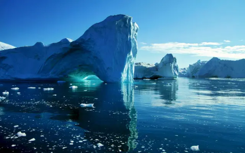

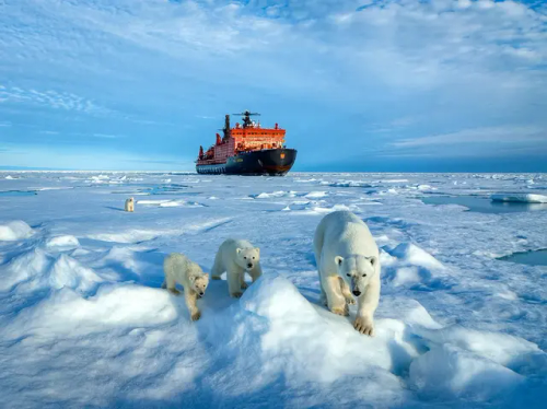


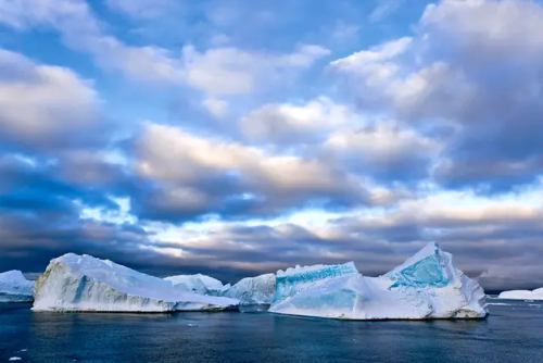
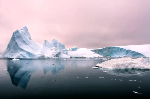


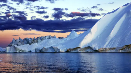
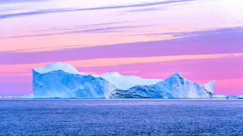


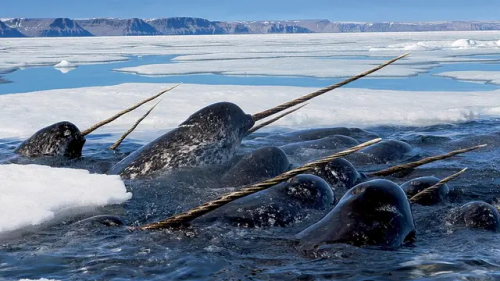


Чарующий и суровый мир Арктики.The enchanting and harsh world of the Arctic.
Источник:://sotni.ru/arkticheskiy-fon/,/vsegda-pomnim.com / priroda/10305-priroda-arktiki-63-foto.html,/cojo.ru/zhivotnye/ zhivotnye-arktiki-53-foto/,/oir.mobi/663890-zhivotnye-arktiki.html, /nlr.ru/nlr_visit/RA5265/novye-postupleniya-arktika--territoriya-mira, /rgo.ru/activity/redaction/articles/kak-vedyet-sebya-arktika-v-epokhu-bystrykh-izmeneniy/,//akspic.ru/tag/arktika/720x1280, //t.me/+E4YBiErj0A8wOGUy.


Азорские острова - край вулканов и гортензий.
Название островов, скорее всего, происходит от устаревшего португальского слова «azures», что буквально означает «голубые». Синего цвета и его оттенков здесь и впрямь много, особенно в мае и начале июня, когда острова покрываются цветущими гортензиями. Жители острова Флорес даже ходят на работу через поля диких гортензий. Азорские острова – это рай для тех, кто любит природу.
The Azores are a land of volcanoes and hydrangeas.
The name of the islands most likely comes from the obsolete Portuguese word "azures", which literally means "blue". There really is a lot of blue and its shades here, especially in May and early June, when the islands are covered with blooming hydrangeas. Residents of the island of Flores even walk to work through fields of wild hydrangeas. The Azores are a paradise for those who love nature.
Источник://t.me/krasivye_mesta_turizm, /ybis.ru/ostrova/azorskie-ostrova-gortenzii,/miss-hohotyn007.livejournal.com /1110530.html, /oir.mobi/704214-azorskie-ostrova-gortenzii.html,/ybis.ru/ostrova/ azorskie-ostrova-gortenzii,/ru.pinterest.com/pin/656047870752312063/, /aaavolkov.livejournal.com/8175.html,klau.club/974-azorskie-ostrova.


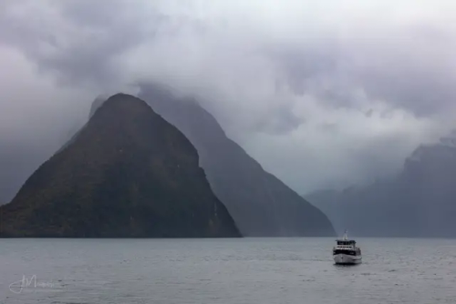


Милфорд Саунд (Milford Sound, маорийское название — Пиопиотахи (Piopiotahi)) – самый знаменитый фьорд в Новой Зеландии, известный на весь мир своей первозданной красотой. Милфорд Саунд, как и фьорды Северного полушария, сформировался в результате деятельности ледника 10-12 тысяч лет назад. Знаменитый английский путешественник и писатель Редьярд Киплинг побывал однажды на берегах Милфорд Саунд и под впечатлением увиденного назвал этот фьорд восьмым чудом света.
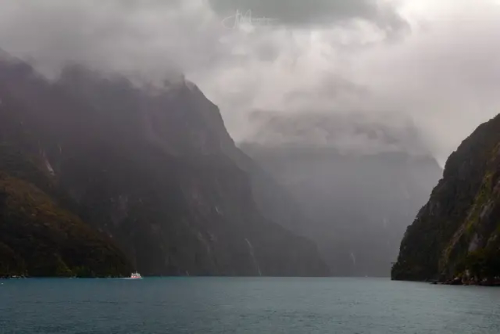
Милфорд Саунд – это вытянутый залив с высокими скалистыми берегами шириной около 3 км, который вдается в сушу на целых 16 км, а максимальная его глубина 512 м. Со всех сторон он окружен горными вершинами, увенчанные вечными снегами, высотой более 1,5 км. Нетронутые человеком густые влажные леса растут здесь практически на отвесных скалах.
Милфорд Саунд - одно из самых влажных мест на Земле, здесь за год выпадает до 7000 мм осадков. Дождь идет каждый день и это сказывается на характере леса - гигантские деревья покрыты мхом и лианами, здесь растут лишайники и папоротники, лес очень влажный. Туристы могут рассчитывать на солнце в течение нескольких часов ближе к полудню, но во второй половине дня их наверняка настигнет ливень.
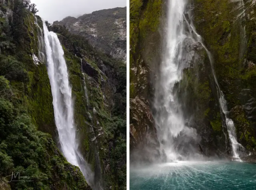
Интересный факт — В дождливые и бурные дни можно увидеть потрясающий природный феномен. Водопады, которые падают вверх. Это явление вызвано географическими особенностями Милфорд Саунда. При встрече с утесом сильный ветер часто поднимается вверх, и обычные водопады, попадая в поток воздуха, кардинально меняют свое направление.
Воды Милфорд Саунд населяет множество тюленей, пингвинов и дельфинов. Исследовательская станция Милфорд Дип позволяет ученым и туристам «заглянуть» в подводный мир. При таком изобилии мелких птиц невозможно обойтись без хищников: в глубине фьорда рассекают толщу воды многочисленные акулы. Также здесь можно увидеть уникальные коралловые рифы, в том числе и самые редкие виды - черные кораллы. Вода в Милфорд Саунд настолько прозрачная, что дно видно даже в самых глубоких местах, если, конечно, его не заслоняют густые водоросли.
Milford Sound (Maori name - Piopiotahi) is the most famous fjord in New Zealand, known throughout the world for its pristine beauty. Milford Sound, like the fjords of the Northern Hemisphere, was formed as a result of glacier activity 10-12 thousand years ago. The famous English traveler and writer Rudyard Kipling once visited the shores of Milford Sound and, impressed by what he saw, called this fjord the eighth wonder of the world.
Milford Sound is an elongated bay with high rocky shores about 3 km wide, which juts into the land for as much as 16 km, and its maximum depth is 512 m. On all sides it is surrounded by mountain peaks, crowned with eternal snow, more than 1.5 km high. Dense rainforests untouched by man grow here almost on sheer cliffs.
Milford Sound is one of the wettest places on Earth, with up to 7,000 mm of rainfall per year. It rains every day and this affects the character of the forest - giant trees are covered with moss and vines, lichens and ferns grow here, the forest is very humid. Tourists can expect sun for a few hours closer to midday, but in the afternoon they will probably be overtaken by a downpour.
Interesting fact - On rainy and stormy days, you can see an amazing natural phenomenon. Waterfalls that fall upwards. This phenomenon is caused by the geographical features of Milford Sound. When meeting a cliff, a strong wind often rises upwards, and ordinary waterfalls, getting into the air flow, radically change their direction.
The waters of Milford Sound are inhabited by many seals, penguins and dolphins. The Milford Deep research station allows scientists and tourists to "look" into the underwater world. With such an abundance of small birds, it is impossible to do without predators: in the depths of the fjord, numerous sharks cut through the water. Here you can also see unique coral reefs, including the rarest species - black corals. The water in Milford Sound is so transparent that the bottom is visible even in the deepest places, unless, of course, it is obscured by thick algae.
Источник: //mirsg.ru/ru/pages/milford-sound,//cattur.ru/australia-and-oceania/new-zealand/milford-saund.html,/australiantravelclub.ru /articles/milford_saund_i_paryashchie_vodopady.htm,/sunsetobsession.com/ru/milford-sound/,/mirsg.ru/ru/pages/milford-sound, /varlamov.ru/1250158.html,//wikiway.com/novaya-zelandiya/milford-saund/,vk.com/@greenfieldworld-novaya-zelandiya-fordlend-milford-saund.
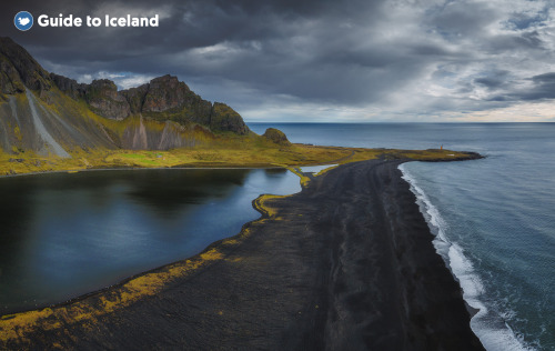
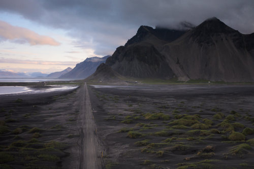

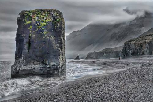
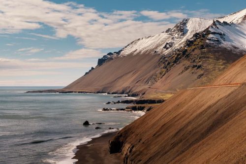
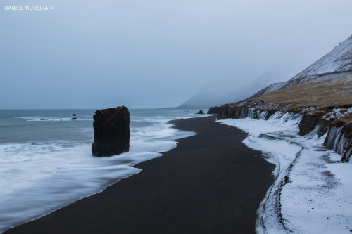
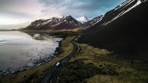
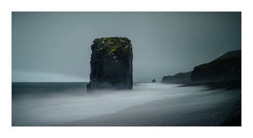
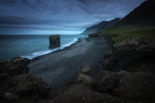
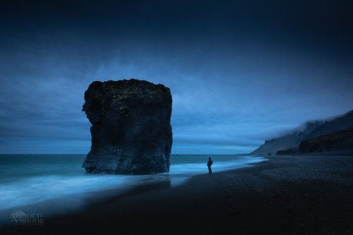
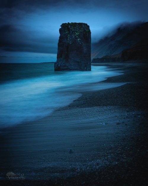
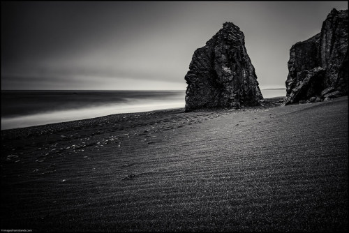
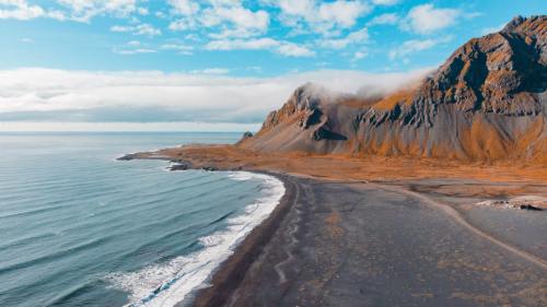
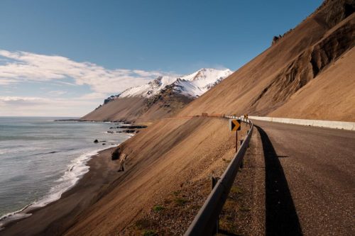
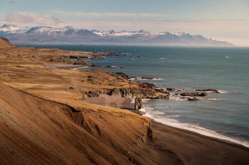
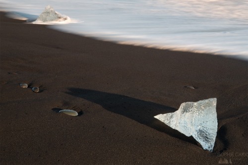
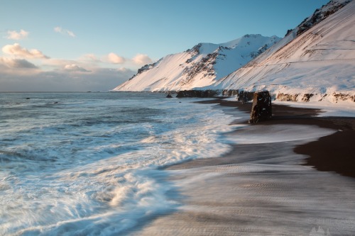
Черный пляж Фаускасандур расположен на южном побережье Исландии, недалеко от небольшого городка Вик-и-Мюрдал. Этот регион характеризуется суровым вулканическим ландшафтом, который является результатом миллионов лет геологической деятельности. До пляжа можно добраться по национальной дороге № 1, известной как Хрингвегур, которая проходит вокруг всей Исландии, соединяя самые важные города и туристические достопримечательности.
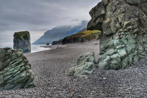
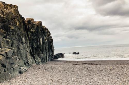
Регион, в котором расположен Фаускасандур, отличается исключительным ландшафтным разнообразием. Рядом с пляжем расположены величественные скалы, вулканические скальные образования и многочисленные пещеры. Одной из самых впечатляющих особенностей ландшафта является гора Рейнисфьялль, которая возвышается над пляжем, откуда открывается захватывающий вид на океан и окрестности.
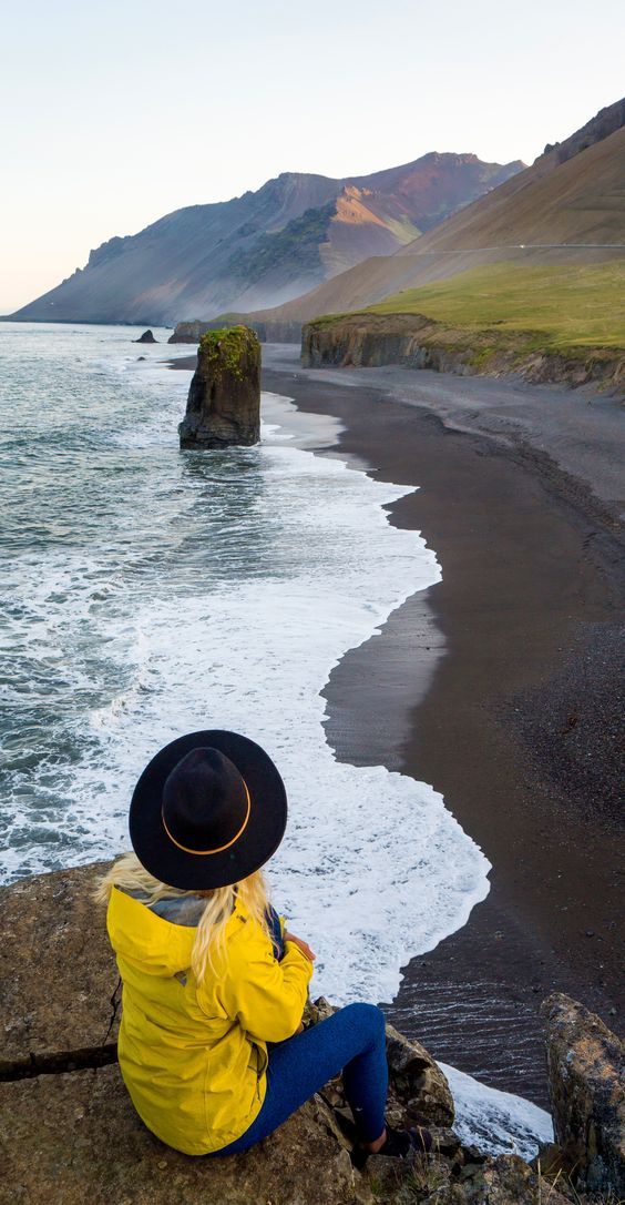
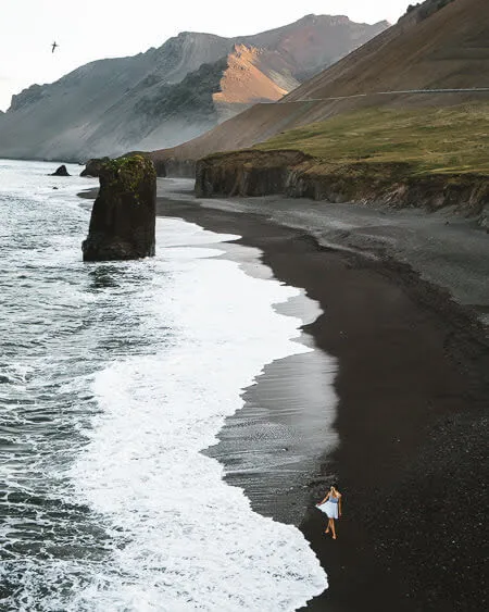
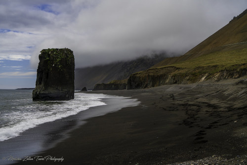
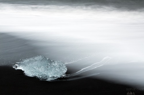
Черный песок пляжа состоит из измельченного базальта, образовавшегося в результате извержений вулканов. Базальтовый песок чрезвычайно мелкий и мягкий, благодаря чему пляж кажется почти сюрреалистическим. Рядом с пляжем можно увидеть впечатляющие базальтовые колонны Рейнисдрангар, которые по легенде являются окаменевшими троллями. Пляж Фаускасандур так же примечателен своим черным песком и огромным монолитом, возвышающимся над его берегом. Почти прямоугольная гигантская скала выглядела неуместно, выступая как недостающая часть окружающих горных оснований. С ее вершиной, покрытой зеленой листвой, которая сползает по скалистым склонам, это естественное скальное образование добавляет уникальный элемент темной береговой линии.Также стоит упомянуть поразительный контраст между белыми изломами в волнах и черным песком.
В целом, уникальный вид Фаускасандура делает его особенно идеальным местом для фотографов. Фаускасандур можно посещать круглый год. Летом, когда погода хорошая, а световой день достигает своей максимальной длины, посетители могут наслаждаться долгими прогулками по песчаному берегу, наблюдая за волнами, разбивающимися о темный песок под полуночным солнцем в течение 20 часов в день. Так же в теплый сезон окрестности становятся зеленее и ярче, а зима подчеркивает завораживающий контраст между белым снегом и черным песком.
The black beach of Fauskasandur is located on the south coast of Iceland, near the small town of Vik y Myrdal. This region is characterized by a rugged volcanic landscape, which is the result of millions of years of geological activity. The beach can be reached via National Road 1, known as Hringvegur, which runs around the entire country of Iceland, connecting the most important cities and tourist attractions.
The region in which Fauskasandur is located has an exceptional landscape diversity. Near the beach there are majestic cliffs, volcanic rock formations and numerous caves. One of the most impressive features of the landscape is the mountain Reynisfjall, which rises above the beach, offering breathtaking views of the ocean and the surrounding area.
The black sand of the beach consists of crushed basalt, formed by volcanic eruptions. Basalt sand is extremely fine and soft, making the beach seem almost surreal. Near the beach, you can see the impressive basalt columns of Reynisdrangar, which according to legend are petrified trolls. Fauskasandur beach is also notable for its black sand and the huge monolith that towers over its shore. The almost rectangular giant rock looked out of place, protruding as a missing part of the surrounding mountain bases. With its top covered in green foliage that creeps down the rocky slopes, this natural rock formation adds a unique element to the dark coastline. Also worth mentioning is the striking contrast between the white breaks in the waves and the black sand.
Overall, Fauskasandur's unique appearance makes it an especially ideal place for photographers. Fauskasandur can be visited all year round. In the summer, when the weather is fine and the daylight hours are at their longest, visitors can enjoy long walks along the sandy shore, watching the waves crash against the dark sand under the midnight sun for 20 hours a day. Also, during the warm season, the surroundings become greener and brighter, and winter highlights the mesmerizing contrast between the white snow and black sand.
Источник://t.me/divo_planeta,/guidetoiceland.is/travel-iceland /drive /fauskasandur-black-sand-beach,/park4night.com/en/place/111259, //sophiecarr.blogspot.com/2018/04/iceland-14-day-7-from-wonderful. html,/www.hatlastravel.com/destination/Iceland/?category=Highland &place=Fauskasandur#pictures,/sandee.com/iceland/east-region/ starmyri/fauskasandur,/ru.gancarczyk.com/Черная-площадь-Фаускасандур-доступ-автостоянка-достопримечательности/, /www.irishroots.pl/czarna-plaza-fauskasandur.htm , /35photo.pro / tags/fauskasandur/.