
197 posts
( ) . , 355 . 1071 . XII , XIII.
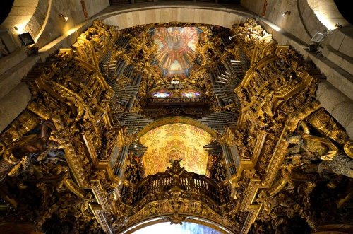


Кафедральный собор Браги (собор пресвятой Девы Марии) — одна из главных достопримечательностей Португалии. Строительство собора было приурочено к освобождению христианами Браги от мавров, захвативших город почти на 355 лет. Первый епископ после восстановления епископской кафедры в 1071 году – Педру – начал строительство храма. Свой окончательный вид собор приобрел только к концу XII века, а полностью достроен был в середине XIII.
Во внешнем виде собора присутствует смешение разнообразных архитектурных стилей. Если первоначально здание собора было построено в романском стиле с бургундским влиянием, то капеллы, позже пристроенные, и предхрамие – это уже готика. Главная аспидная часть исполнена в стиле мануэлино. Церковный фасад украшают две высокие колокольни, а по центру между гербами Португалии и Диего де Сауса возвышается Божья Матерь, кормящая младенца. Архитектурный ансамбль богато украшен орнаментами, фризами, скульптурными композициями, изображающими святых, животных и химер.
Внутреннее убранство поражает роскошью. Главный алтарь архитектора Жуана де Кастилью изыскано, украшено золотом. Над центральным нефом расположены два старинных органа. Барочный ансамбль щедро оснащен резным орнаментом. Собор имеет пять капелл, каждая из которых заслуживает внимания. Особо выделяется усыпальница архиепископа Гонсалу Перейры, резной каменный саркофаг (1331 год) архитектора Телу Гарсия и надгробная статуя, работа Перу. Эти элементы считаются шедевром средневековой португальской архитектуры. Гробница находится под охраной шести каменных львов.
В остальных капеллах захоронены значимые политические деятели и почитаемые личности – Генрих Бургундский, Тереза Леонская, Афонсу Португальский и другие. Еще с XVII века в музее собора формируется коллекция колоколов. Уже собрано более 200 экземпляров. Тут же представлены ювелирные изделия, живопись и скульптуры религиозной тематики. Кафедральный собор Браги находится в историческом центре города и буквально окружен архитектурными шедеврами. В радиусе 200 метров от собора находится Церковь Милосердия, Епископский Дворец, Церковь Сан-Жуан-ду-Суто, Капелла Куимбраш.
The Cathedral of Braga (Cathedral of the Blessed Virgin Mary) is one of the main attractions of Portugal. The construction of the cathedral was timed to coincide with the liberation of Braga by Christians from the Moors, who captured the city for almost 355 years. The first bishop after the restoration of the episcopal see in 1071, Pedro– began the construction of the temple. The cathedral acquired its final appearance only by the end of the XII century, and was completely completed in the middle of the XIII century.
In the exterior of the cathedral there is a mixture of various architectural styles. If the original building of the cathedral was built in the Romanesque style with a Burgundian influence, then the chapels, later added, and the pre–temple are already Gothic. The main viper part is executed in the Manueline style. The church facade is decorated with two tall bell towers, and in the center between the coats of arms of Portugal and Diego de Sausa stands the Mother of God nursing a baby. The architectural ensemble is richly decorated with ornaments, friezes, sculptural compositions depicting saints, animals and chimeras. The interior is striking in luxury. The main altar of the architect Juan de Castilla is exquisitely decorated with gold. Two ancient organs are located above the central nave. The Baroque ensemble is generously equipped with carved ornaments. The cathedral has five chapels, each of which deserves attention. The tomb of Archbishop Gonzalo Pereira, the carved stone sarcophagus (1331) by architect Telo Garcia and the tombstone statue, the work of Peru, stand out in particular. These elements are considered a masterpiece of medieval Portuguese architecture. The tomb is guarded by six stone lions.
In the other chapels, significant political figures and revered personalities are buried – Henry of Burgundy, Teresa of Leon, Afonso of Portugal and others. Since the XVII century, a collection of bells has been formed in the cathedral museum. More than 200 copies have already been collected. Jewelry, paintings and sculptures of religious themes are also presented here. The Cathedral of Braga is located in the historical center of the city and is literally surrounded by architectural masterpieces. Within a radius of 200 meters from the cathedral there is the Church of Mercy, the Episcopal Palace, the Church of San Juan do Suto, the Chapel of Cuimbrache.
Источник://telega.in/c/krasivye_mesta_turizm,/uritsk.livejournal.com/198306.html,/fotobrodilki.ru/braga-portugal/, /disk.yandex.ru/ a/ 5gXImKWa3VkYAG,/www.tourister.ru/world/europe/portugal/city/braga/temples/15876/responses/7805,://rutraveller.ru/place/97732/photos?fs=1820878, /www.turizm.ru/portugal/braga/places/ kafedralnyj _ sobor_bragi/,Attraction_Review-g189171-d318707-Reviews-Se_de_Braga-Braga_Braga_District_Northern_Portugal.html.
-
 trannypanny liked this · 7 months ago
 -
 prax0deda liked this · 7 months ago
 -
 angelayasmim liked this · 8 months ago
 -
 kevinkenterprisemjensemble18th reblogged this · 8 months ago
 -
kevinkenterprisemjensemble18th liked this · 8 months ago
-
 vihangam liked this · 8 months ago
 -
vihangam reblogged this · 8 months ago
-
 imsoboredpleasesomebodyhelpme liked this · 8 months ago
 -
 dream-world-universe liked this · 8 months ago
 -
 senia-st liked this · 8 months ago
 -
 northameicanblog liked this · 9 months ago
 -
 iamblessedtruly liked this · 9 months ago
 -
 luna-fantasma liked this · 9 months ago
 -
 ludmila199 liked this · 9 months ago
 -
 j0njack liked this · 9 months ago
 -
 m-1-l-a-g-r-o-10-16 liked this · 9 months ago
 -
 qwerty292 liked this · 9 months ago
 -
 kafka-mono liked this · 9 months ago
 -
gentilhommejfgh liked this · 9 months ago
-
 mdoubledos liked this · 9 months ago
 -
 danycolombia liked this · 9 months ago
 -
 kukkikuko reblogged this · 9 months ago
 -
 khan-aitmatov reblogged this · 9 months ago
 -
khan-aitmatov liked this · 9 months ago
-
 christabelq liked this · 9 months ago
 -
winstonwillow liked this · 10 months ago
-
 phantomofthering liked this · 10 months ago
 -
 jessiemoonsims liked this · 10 months ago
 -
 imortellekim liked this · 10 months ago
 -
macieknewman reblogged this · 10 months ago
-
macieknewman liked this · 10 months ago
-
 gloriouslyscentedwizard reblogged this · 10 months ago
 -
gloriouslyscentedwizard liked this · 10 months ago
-
 aquariusletthesunshine reblogged this · 10 months ago
 -
aquariusletthesunshine liked this · 10 months ago
-
 mimimoye liked this · 10 months ago
 -
 huzur-un liked this · 10 months ago
 -
 berkelygenerator liked this · 10 months ago
 -
 regina1533 liked this · 10 months ago
 -
 cikinadam liked this · 10 months ago
 -
 williamskyw liked this · 10 months ago
 -
 vuonkhuya liked this · 10 months ago
 -
 kojj liked this · 10 months ago
 -
 vivencias-del-alma liked this · 10 months ago
 -
 thethirdman8 liked this · 10 months ago
More Posts from Vestaignis


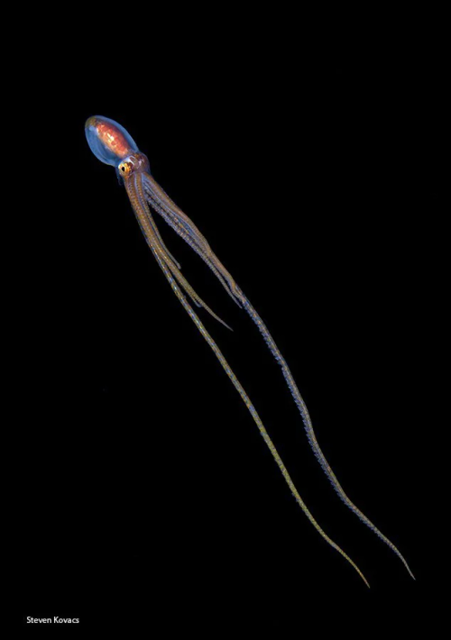


Macrotritopus defilippi, широко известный как длиннорукий осьминог-лилипут или атлантический длиннорукий осьминог, является небольшим видом осьминогов, морских головоногих моллюсков отряда Octopoda.
Macrotritopus defilippi - это небольшой осьминог с относительно длинными руками и мантией длиной до 90 мм (3,5 дюйма). Как и у большинства осьминогов, цвет кожи может варьироваться. Обычно он либо однотонный, либо в крапинку и полностью соответствует цвету окружающей местности, песчаных равнин, на которых он обитает. Там, где субстрат содержит гравий или песок, крапчатый рисунок часто крупнее, на коже могут быть небольшие сосочки (мясистые выпуклости), а на руках - светлые и темные полосы. Этот осьминог также может зарываться в субстрат, не оставляя никаких визуальных следов своего местонахождения.
Личинки Macrotritopus defilippi плавают с вытянутыми лапками и, если их потревожить, взлетают с помощью реактивного двигателя, иногда достигая морского дна и ища нору, в которой можно спрятаться. Ночью они могут вести пелагический образ жизни, а днем - бентический, но, по-видимому, с возрастом становятся менее ночными. Когда взрослая особь осьминога передвигается, то делает это таким образом, что его поведение при плавании очень напоминает поведение донных камбал, обитающих в тех же водах.
Macrotritopus defilippi был обнаружен в Атлантическом океане, включая Карибское море, Средиземное море, северную часть Индийского океана и побережье Сомали.
Macrotritopus defilippi, commonly known as the long-armed midget octopus or Atlantic long-armed octopus, is a small species of octopus, marine cephalopods of the order Octopoda.
Macrotritopus defilippi is a small octopus with relatively long arms and a mantle up to 90 mm (3.5 in) long. As with most octopuses, skin color can vary. It is usually either monophonic or speckled and fully corresponds to the color of the surrounding area, the sandy plains on which it lives. Where the substrate contains gravel or sand, the speckled pattern is often larger, there may be small papillae (fleshy bulges) on the skin, and light and dark stripes on the hands. This octopus can also burrow into the substrate without leaving any visual traces of its location.
Macrotritopus defilippi larvae swim with their legs outstretched and, if disturbed, take off using a jet engine, sometimes reaching the seabed and looking for a hole in which to hide. They can lead a pelagic lifestyle at night and a benthic lifestyle during the day, but apparently they become less nocturnal with age. When an adult octopus moves, it does so in such a way that its swimming behavior is very similar to that of bottom flounders living in the same waters.
Macrotritopus defilippi has been found in the Atlantic Ocean, including the Caribbean Sea, the Mediterranean Sea, the northern Indian Ocean and the coast of Somalia.
Источник://t.me/+E4YBiErj0A8wOGUy,//news.miami.edu/stories/2019/06/winners-announced-in-rosenstiel-school-underwater-photo-contest.html,//ru.pinterest.com/pin/632966922633183935/,/octonation.com/octopedia/atlantic-longarm-octopus/,//pofoto.club/17356-glubokovodnyj-osminog-57-foto.html, //en.wikipedia.org/ wiki/ Macrotritopus_defilippi.
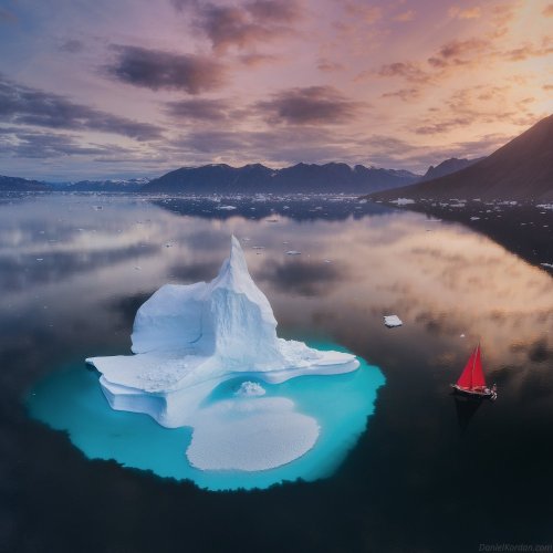
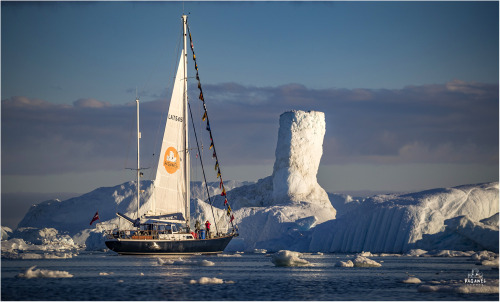
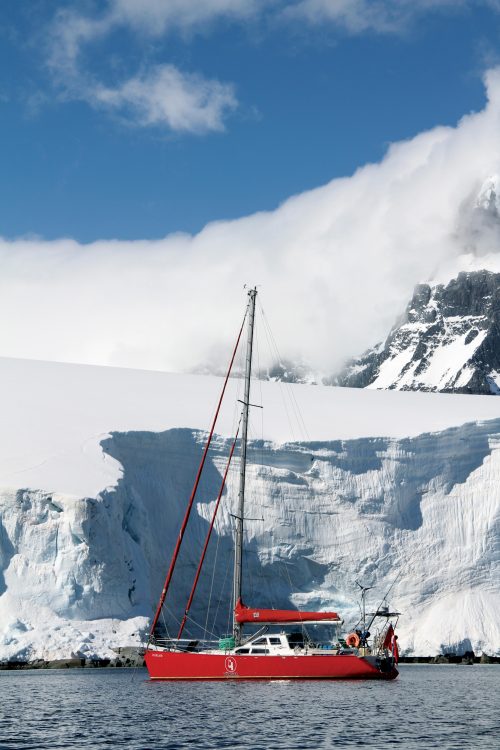
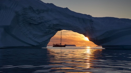
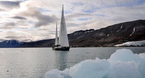

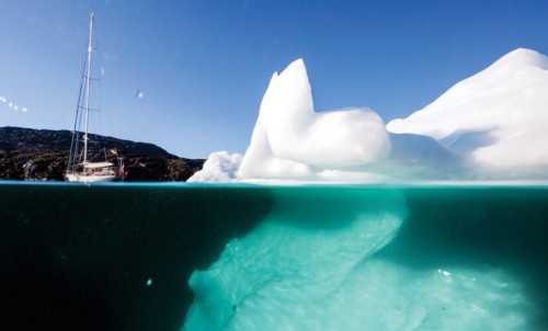
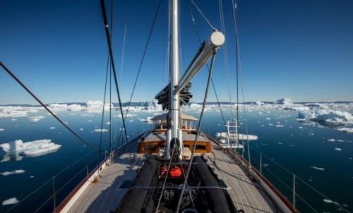
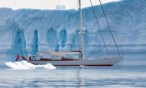
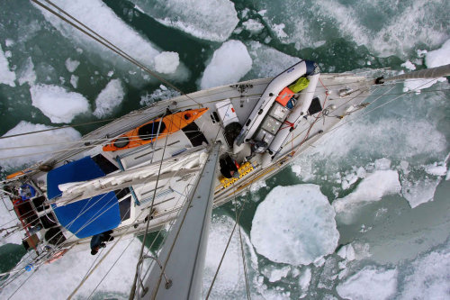
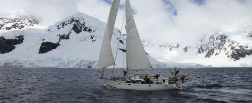
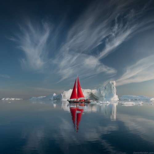

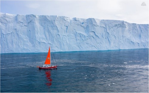
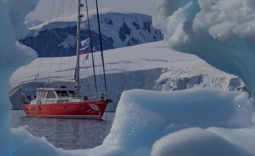
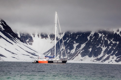
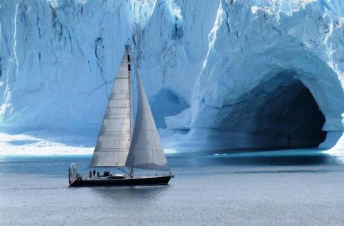
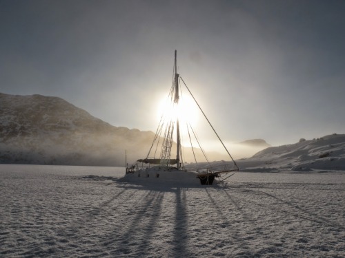
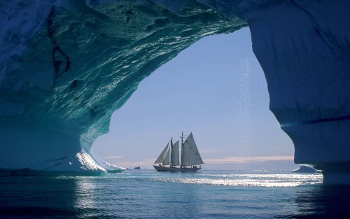
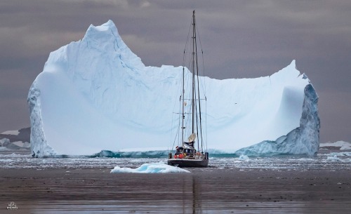
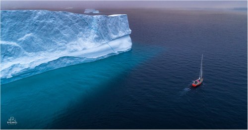
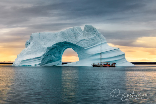
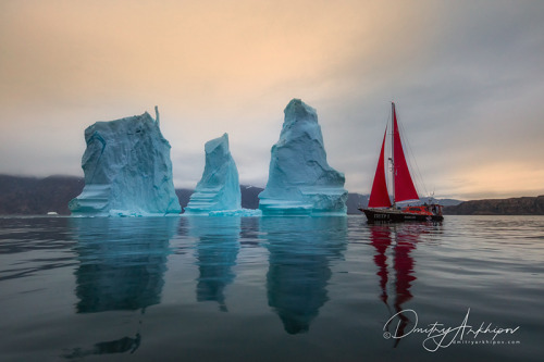
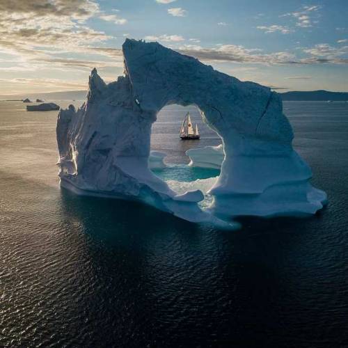
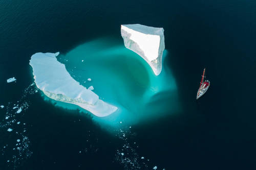
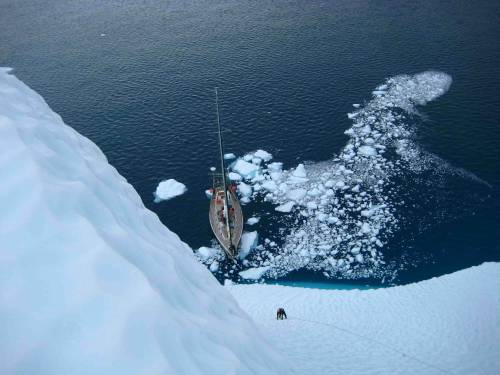
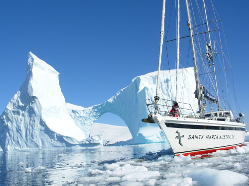
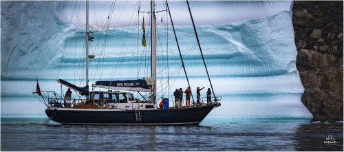
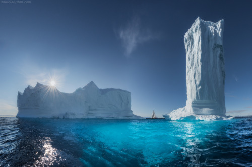
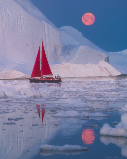
Под парусом в царстве льда и воды, неба и скал. Sailing in the kingdom of ice and water, sky and rocks.
Источник://t.me/roundtravel,/myskillsconnect.com/vodnyj-transport/ 41987-krejserskaja-jahta-antarktika-56-foto.html,/dmitryarkhipov.ru / phototur-greenland-rus,/interparus.com/sailing-greenland-superyacht -acadia/,//www.steelratboat.ru/436/yachts-in-the-ice,/wildrussia.travel /tur-v-antarktidu-na-yaxte-pod-parusami?,://35photo.pro/tags/Гренландия.


Каинды - 400 метровое озеро в Казахстане, в долине Тянь-Шаня, в 129 км от города Алматы. Оно расположено среди хвойного леса на высоте 1667 метров над уровнем моря. Озеро Каинды образовалось после землетрясения 1911 года, которое вызвало большой оползень, заблокировавший одно из ущелий горного хребта Кунгей Алатау, образовав естественную плотину. Впоследствии, дождевая вода заполнила долину и наполнила озеро.
Озеро славится своей красотой подводного леса. Макушки самых высоких деревьев поднимаются прямо из воды. Средняя глубина составляет 20 метров, а в некоторых местах доходит до 30 метров. Вода в озере настолько холодная (даже летом температура воды не превышает 6 градусов), что могучие сосны по-прежнему остаются полузамороженными на своих местах, даже 100 лет спустя. Благодаря чистой горной воде, можно увидеть глубины озера. Вода в озере пресная, практически не содержит растворенных солей и идентична той воде, которая подвергается многоуровневой очистке в лаборатории.Зимой поверхность озера замерзает и становится прекрасным местом для ловли форели и подлёдного дайвинга.
Этот природный объект внесён в список особо охраняемых природных территорий со статусом природоохранного и научного учреждения, а также входит в Государственный национальный природный парк "Кольсайские озёра".
Kaindy is a 400-meter lake in Kazakhstan, in the Tien Shan Valley, 129 km from the city of Almaty. It is located among a coniferous forest at an altitude of 1667 meters above sea level. Kaindy Lake was formed after the earthquake of 1911, which caused a large landslide that blocked one of the gorges of the Kungei Alatau mountain range, forming a natural dam. Subsequently, rainwater filled the valley and filled the lake.
The lake is famous for its underwater forest beauty. The tops of the tallest trees rise straight out of the water. The average depth is 20 meters, and in some places it reaches up to 30 meters. The water in the lake is so cold (even in summer the water temperature does not exceed 6 degrees) that the mighty pines still remain semi-frozen in their places, even 100 years later. Thanks to the clear mountain water, you can see the depths of the lake. The water in the lake is fresh, contains practically no dissolved salts and is identical to the water that is subjected to multi-level purification in the laboratory.In winter, the surface of the lake freezes and becomes a great place for trout fishing and ice diving.
This natural object is included in the list of specially protected natural territories with the status of an environmental and scientific institution, and is also included in the Kolsai Lakes State National Natural Park.
Источник://discoverynn.ru/blog/kazakhstan/ozero-kaindy-neobychnaya-dostoprimechatelnost-na-yuge-kazakhstana/ , ://newtimes.kz/obshchestvo/155196-podvodnyj-les-ozera-kaindy-udivil-kazahstancev,//tourlenta.com/blog/316-podvodnij-les-na-ozere-kaindi,m.vk.com/wall-222521402_9950,//www.stena.ee /blog /zatoplennyj-les-odno-iz-samyh-krasivyh-mest-kazahstana,//dzen.ru /a/ZOZQ8LxcWxUAPkQe,aveneerdmc.com/ru/inspiration/kaindy.
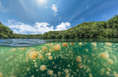
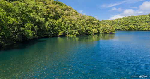
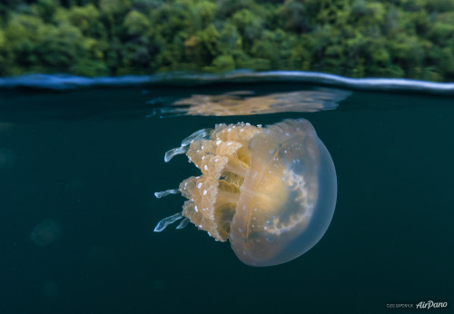
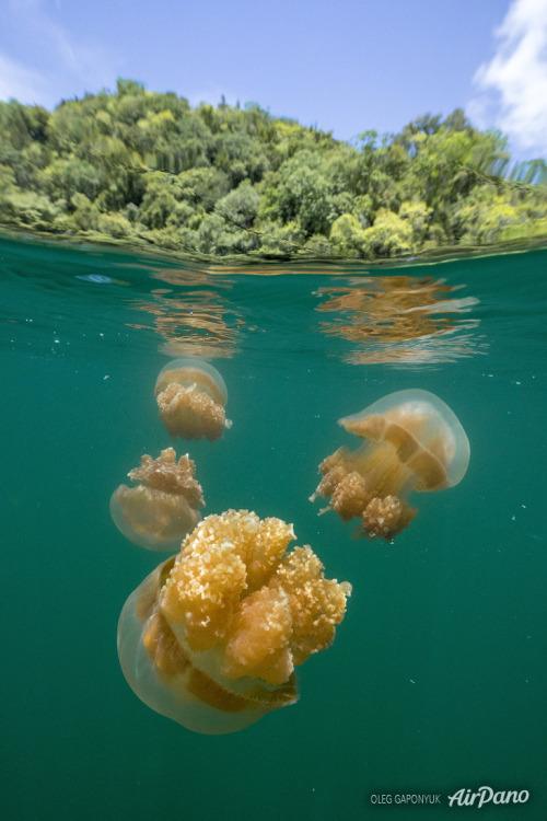
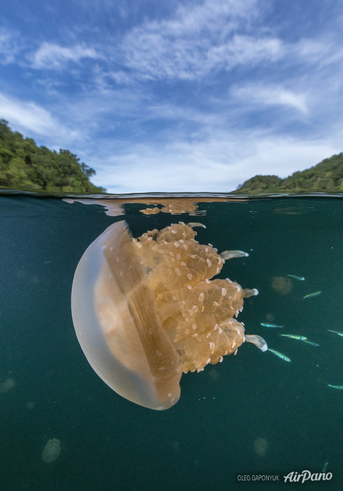
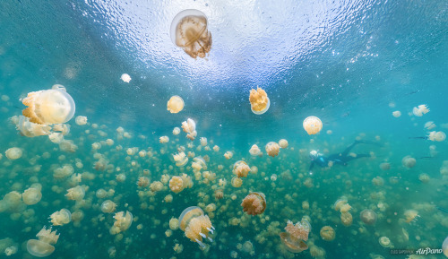
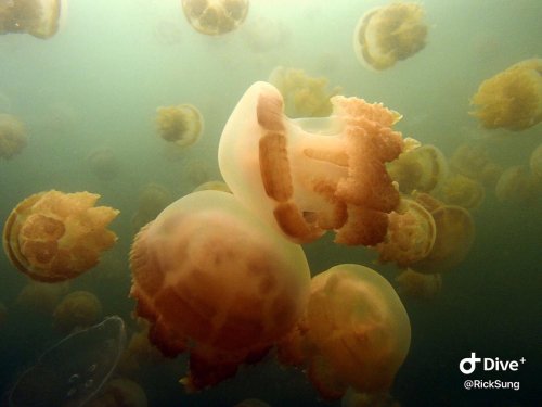
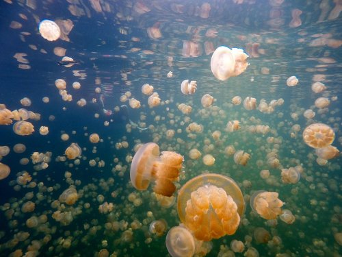
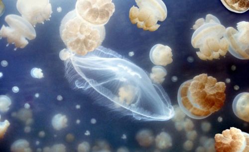
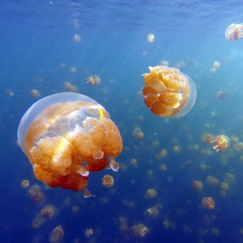
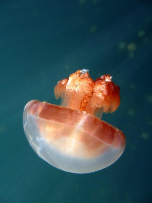
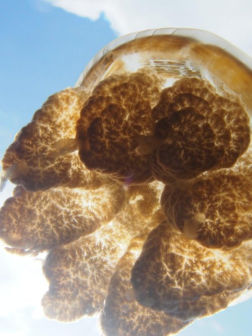
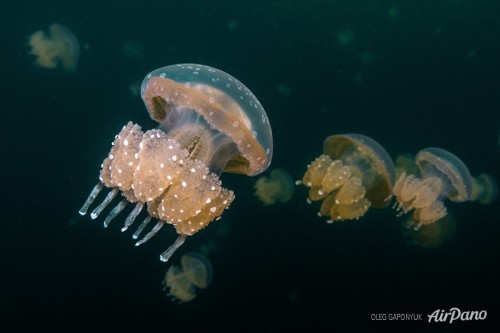
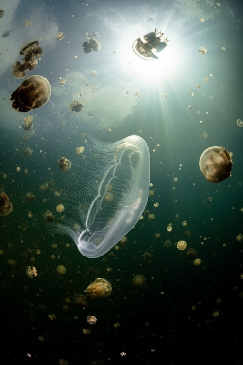
Озеро Медуз — озеро в архипелаге Скалистые острова (Палау). Озеро расположено на востоке острова Эйл-Малк, в более чем 20 км к юго-востоку от Корора. Этот естественный слабо-солёный водоем имеет глубину до 50 метров и размеры всего 460 м на 160 м, он сообщается с расположенным примерно в 200 метрах Тихим океаном через трещины и поры в горной породе.
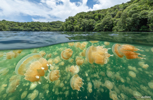
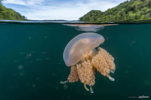
Озеро Медуз разделено на два слоя — бескислородный и с большим содержанием кислорода. Первый, нижний слой (приблизительно от глубины 15 метров и до дна) обладает высокой концентрацией аммиака и фосфатов, чем опасен для дайверов, которые могут получить отравление через кожу. В этом слое живут только бактерии. Зато другой слой, насыщенный кислородом (примерно до глубины 15 м), населяют разнообразные микроорганизмы, несколько видов рыб и веслоногих ракообразных и, конечно же, медузы.
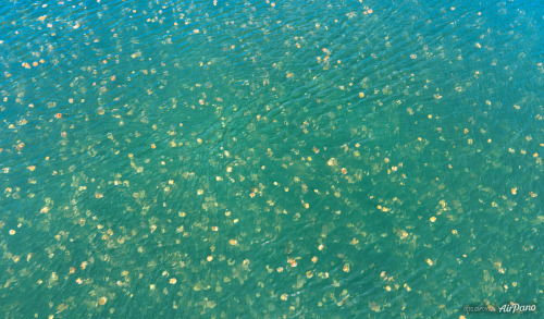
Образованное движением земной коры более 12 000 лет назад озеро известно своей обособленной популяцией двух видов сцифоидных — золотая медуза (Mastigias papua) и лунная медуза (Aurelia). За время, проведенное вдали от моря, живущие здесь золотисто-оранжевые медузы эволюционировали и утратили свою способность жалить. Весь день они следуют за солнцем, перемещаясь по глади озера, а к ночи опускаются на дно, где подпитываются водорослями. Лунные медузы питаются веслоногими ракообразными, для чего ночью поднимаются на поверхность озера. Считается,что общая численность медуз, обитающих в этом необычном озере, достигает двух миллионов особей. Количество медуз так велико, что их массу легко можно заметить, даже находясь в самолете. Золотая медуза имеет огромное численное превосходство над лунной.
Кроме того, в озере Медуз не разрешено нырять с аквалангом. Воздушные пузырьки, которые образуются во время дыхания аквалангиста, попадают под купол медузы и могут привести к ее гибели. По этим причинам в озере плавают только в верхнем слое воды, используя ласты и маску. Погружение в воды этого медузового озера – удивительная возможность попасть в иной мир, оказавшись в самом центре гипнотического танца медуз.
Jellyfish Lake is a lake in the Rocky Islands archipelago (Palau). The lake is located on the east of Eil Malk Island, more than 20 km southeast of Koror. This natural, slightly saline body of water is up to 50 meters deep and measures just 460 m by 160 m, connecting to the Pacific Ocean about 200 meters away through cracks and pores in the rock.
Jellyfish Lake is divided into two layers: anoxic and highly oxygenated. The first, lower layer (from approximately a depth of 15 meters to the bottom) has a high concentration of ammonia and phosphates, which is dangerous for divers, who can become poisoned through the skin. Only bacteria live in this layer. But another layer, saturated with oxygen (to about a depth of 15 m), is inhabited by a variety of microorganisms, several species of fish and copepods and, of course, jellyfish.
Formed by the movement of the earth's crust over 12,000 years ago, the lake is known for its distinct population of two scyphoid species - the golden jellyfish (Mastigias papua) and the moon jellyfish (Aurelia). During their time away from the sea, the golden-orange jellyfish that live here have evolved and lost their ability to sting. All day they follow the sun, moving along the surface of the lake, and by night they sink to the bottom, where they feed on algae. Moon jellyfish feed on copepods, for which they rise to the surface of the lake at night. It is believed that the total number of jellyfish living in this unusual lake reaches two million individuals. The number of jellyfish is so large that their mass can be easily noticed even while on an airplane. The golden jellyfish has a huge numerical superiority over the lunar jellyfish.
Additionally, scuba diving is not allowed in Jellyfish Lake. Air bubbles that form during the scuba diver's breathing fall under the dome of the jellyfish and can lead to its death.For these reasons, people swim in the lake only in the upper layer of water, using fins and a mask. Diving into the waters of this jellyfish lake is an amazing opportunity to enter another world, finding yourself in the very center of the hypnotic dance of jellyfish.
Источник: //www.stepandstep.ru/biologiya/ozero-meduz, //cameralabs.org/aeon/fotokonkurs-siena-international-awards /foto/ 46069-pooshchritelnaya-premiya-v-kategorii-krasota-prirody-2021-ozero-meduz-avtor-khenli-spajers,//www.cawater-info.net /all_about _water/?p=14456,dzen.ru/a/XbytncBccQCufY29, //topwonders .ru / palau/ozero-meduz-na-palau.html,omyworld.ru/9937,//www. stepandstep.ru/biologiya/ozero-meduz/,/www.airpano.ru /360article / jellyfish-lake-palau/,/www.tripadvisor.ru/Attraction_Review-g294136-d795830-Reviews-Jellyfish_Lake-Koror_Koror_Island.html.
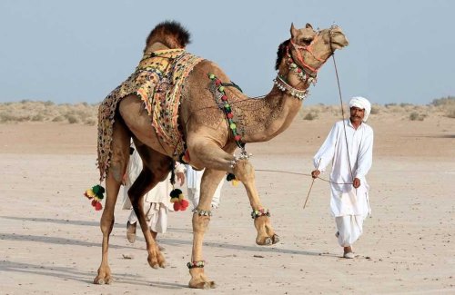
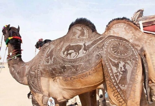
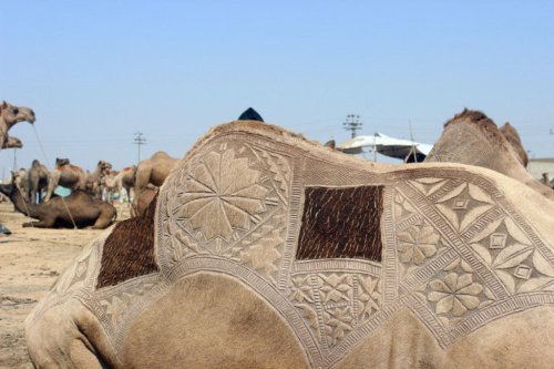
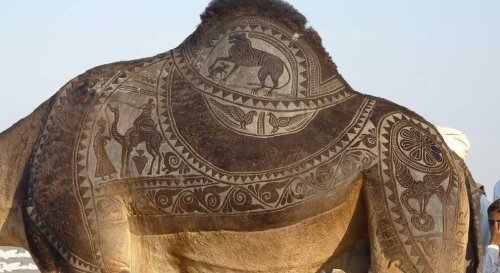
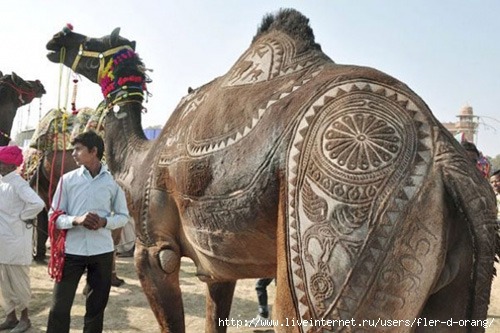
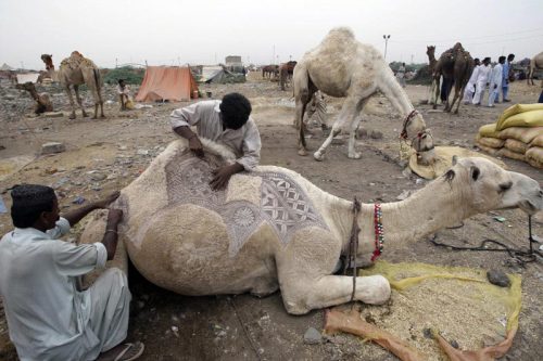
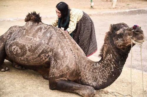
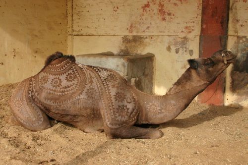
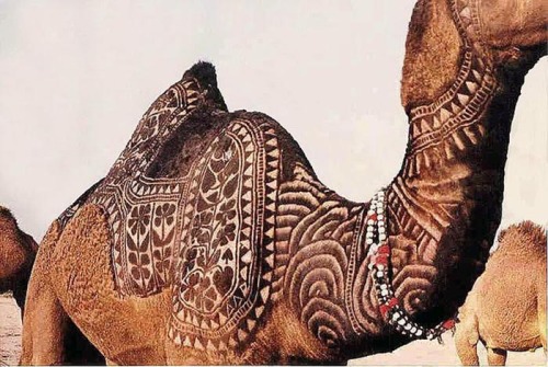
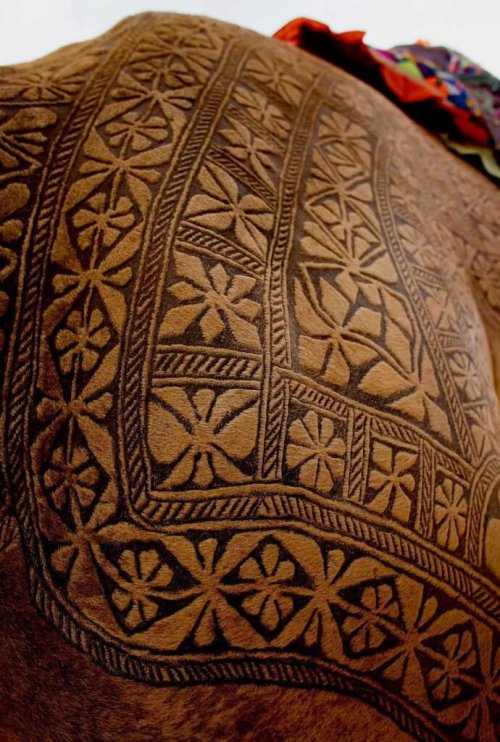
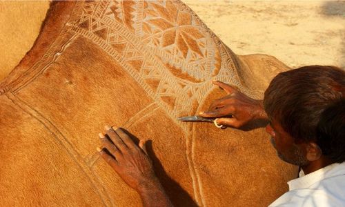
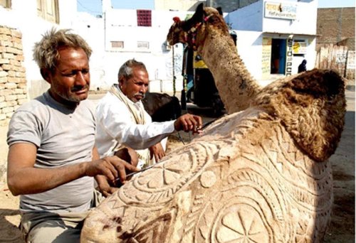
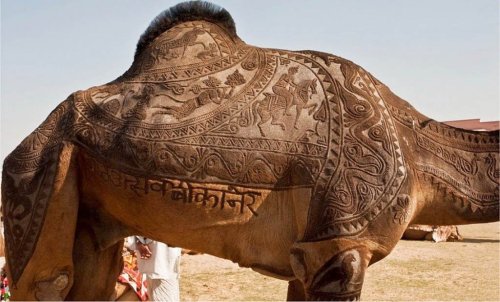
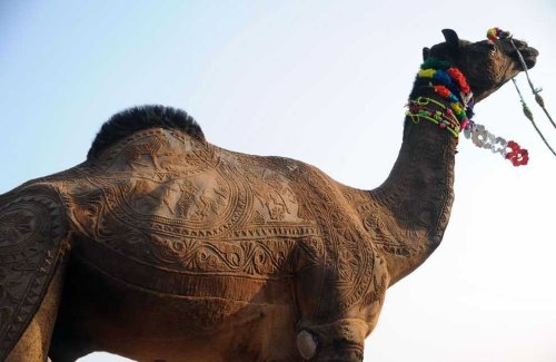
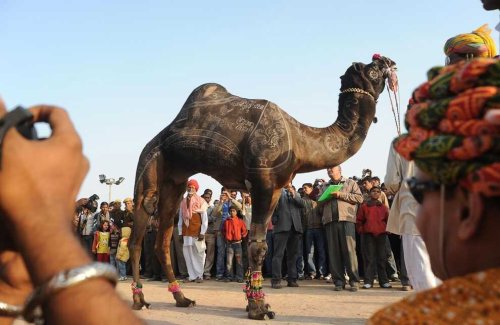
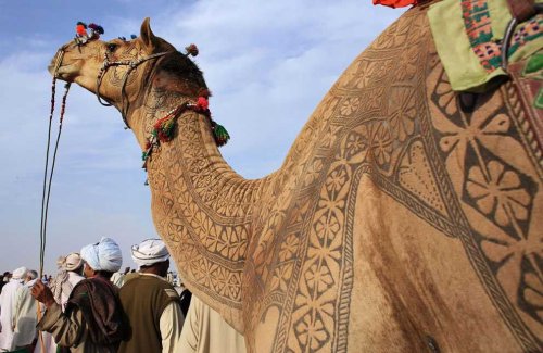
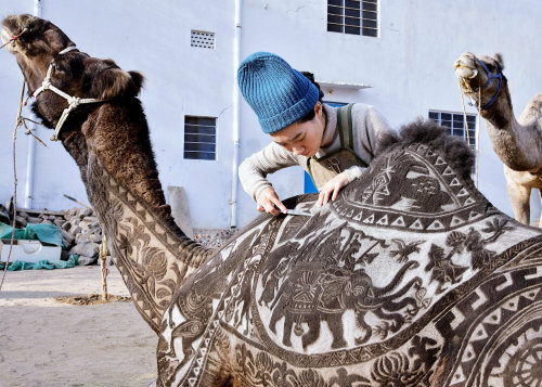
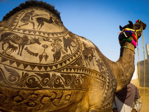
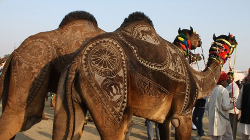
В Индии фестиваль верблюдов – одно из самых красивых и запоминающихся событий в стране. Проходит фестиваль в индийском городе Биканер в штате Раджастан. Биканер находится в пустыне Тар и знаменит тем, что именно в нем расположена единственная в Индии ферма верблюдов.
Изюминка этого праздника - оригинальный верблюжий карвинг. Карвинг по шерсти (так называется художественная стрижка верблюдов) - это искусство, которое требует не только высокого уровня профессионализма и определенных навыков, но и нескончаемого терпения. Верблюдов стригут особым образом, создавая на теле изысканные узоры. На создание такой оригинальной прически хозяину животного нужно около трех лет. Первые два года, пока шерсть верблюда отрастает, ее только подравнивают и подготавливают. А на третий год, когда шерсть вырастает нужной длины, перед началом фестиваля ее аккуратно выстригают в виде различных орнаментов на спине, боках и шее верблюда. Причем делается все это только вручную, с помощью обыкновенных ножниц.
Некоторые счастливые владельцы не останавливаются и на этом – они подкрашивают выборочно кончики волос в более темный цвет, чтобы рисунок выглядел эффектнее и рельефнее. Так получается настоящее произведение искусства, живой ковер с узорами удивительной красоты. Для конкурса красоты верблюдов также украшают различными красочными аксессуарами.
In India, the camel festival is one of the most beautiful and memorable events in the country. The festival is taking place in the Indian city of Bikaner in the state of Rajasthan. Bikaner is located in the Thar desert and is famous for the fact that it is the only camel farm in India.
The highlight of this holiday is the original camel carving. Wool carving (the so-called artistic camel shearing) is an art that requires not only a high level of professionalism and certain skills, but also endless patience. Camels are sheared in a special way, creating exquisite patterns on the body. It takes about three years for the owner of the animal to create such an original hairstyle. For the first two years, while the camel's hair grows, it is only trimmed and prepared. And in the third year, when the wool grows to the desired length, before the start of the festival it is carefully cut in the form of various ornaments on the camel's back, sides and neck. Moreover, all this is done only manually, using ordinary scissors.
Some happy owners do not stop there either – they selectively tint the ends of their hair in a darker color so that the pattern looks more spectacular and more relief. So it turns out to be a real work of art, a living carpet with patterns of amazing beauty. Camels are also decorated with various colorful accessories for the beauty contest.
Источник:/ekabu.ru/160021-verblyuzhiy-bodi-art-18-foto.html, /astv.ru/club/blog/utro/6jXTE7Xkd02AQEOfZY-8Fg, /multiurok.ru / blog/nieobychnyi-vid-iskusstva-vierbliuzhii-bodiart.html, //dzen.ru /a /YndBAXlNcTNWFXvW.